You are here: Home > Network List > TA - USArray Transportable Network (new EarthScope stations) Stations List
> Station H31A Wolsey, SD, USA > Earthquake Result Viewer
H31A Wolsey, SD, USA - Earthquake Result Viewer
| Earthquake location: |
Off East Coast Of Honshu, Japan |
| Earthquake latitude/longitude: |
39.5/143.2 |
| Earthquake time(UTC): |
2012/05/20 (141) 07:19:54 GMT |
| Earthquake Depth: |
11 km |
| Earthquake Magnitude: |
5.6 MB |
| Earthquake Catalog/Contributor: |
WHDF/NEIC |
|
| Network: |
TA USArray Transportable Network (new EarthScope stations) |
| Station: |
H31A Wolsey, SD, USA |
| Lat/Lon: |
44.48 N/98.48 W |
| Elevation: |
415 m |
|
| Distance: |
79.6 deg |
| Az: |
39.865 deg |
| Baz: |
316.186 deg |
| Ray Param: |
0.048852473 |
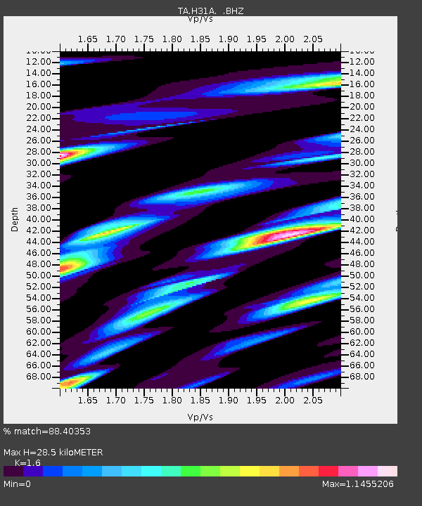
| Estimated Moho Depth: |
28.5 km |
| Estimated Crust Vp/Vs: |
1.60 |
| Assumed Crust Vp: |
6.53 km/s |
| Estimated Crust Vs: |
4.082 km/s |
| Estimated Crust Poisson's Ratio: |
0.18 |
|
| Radial Match: |
88.40353 % |
| Radial Bump: |
400 |
| Transverse Match: |
77.55218 % |
| Transverse Bump: |
400 |
| SOD ConfigId: |
446234 |
| Insert Time: |
2012-08-25 18:26:33.420 +0000 |
| GWidth: |
2.5 |
| Max Bumps: |
400 |
| Tol: |
0.001 |
|
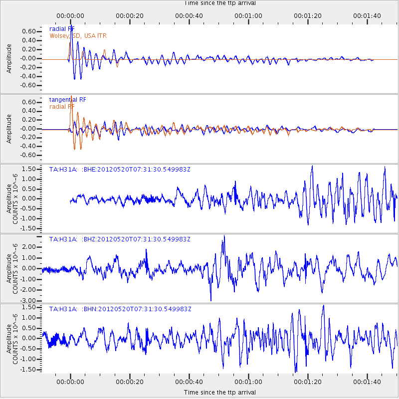
Signal To Noise
| Channel | StoN | STA | LTA |
| TA:H31A: :BHZ:20120520T07:31:30.549983Z | 1.905849 | 3.2218415E-7 | 1.690502E-7 |
| TA:H31A: :BHN:20120520T07:31:30.549983Z | 1.076542 | 2.4559304E-7 | 2.281314E-7 |
| TA:H31A: :BHE:20120520T07:31:30.549983Z | 0.9637039 | 1.2389498E-7 | 1.2856125E-7 |
| Arrivals |
| Ps | 2.7 SECOND |
| PpPs | 11 SECOND |
| PsPs/PpSs | 14 SECOND |


