You are here: Home > Network List > TA - USArray Transportable Network (new EarthScope stations) Stations List
> Station E35A Pequot Lakes, MN, USA > Earthquake Result Viewer
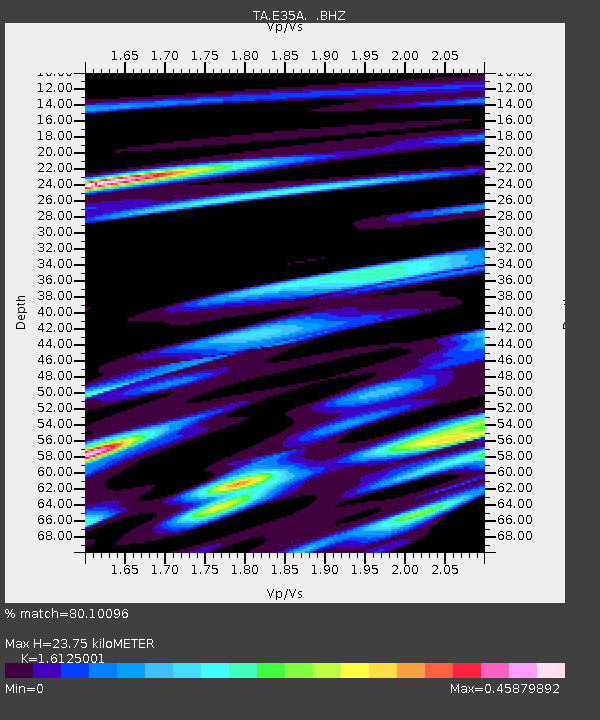
E35A Pequot Lakes, MN, USA - Earthquake Result Viewer
| Earthquake location: |
Off East Coast Of Honshu, Japan |
| Earthquake latitude/longitude: |
39.5/143.2 |
| Earthquake time(UTC): |
2012/05/20 (141) 07:19:54 GMT |
| Earthquake Depth: |
11 km |
| Earthquake Magnitude: |
5.6 MB |
| Earthquake Catalog/Contributor: |
WHDF/NEIC |
|
| Network: |
TA USArray Transportable Network (new EarthScope stations) |
| Station: |
E35A Pequot Lakes, MN, USA |
| Lat/Lon: |
46.56 N/94.40 W |
| Elevation: |
409 m |
|
| Distance: |
80.0 deg |
| Az: |
36.296 deg |
| Baz: |
318.451 deg |
| Ray Param: |
0.048568662 |
| Estimated Moho Depth: |
23.75 km |
| Estimated Crust Vp/Vs: |
1.61 |
| Assumed Crust Vp: |
6.419 km/s |
| Estimated Crust Vs: |
3.981 km/s |
| Estimated Crust Poisson's Ratio: |
0.19 |
|
| Radial Match: |
80.10096 % |
| Radial Bump: |
400 |
| Transverse Match: |
61.331623 % |
| Transverse Bump: |
400 |
| SOD ConfigId: |
446234 |
| Insert Time: |
2012-08-25 18:27:03.085 +0000 |
| GWidth: |
2.5 |
| Max Bumps: |
400 |
| Tol: |
0.001 |
|

Signal To Noise
| Channel | StoN | STA | LTA |
| TA:E35A: :BHZ:20120520T07:31:32.77502Z | 2.205779 | 2.5761307E-7 | 1.1679007E-7 |
| TA:E35A: :BHN:20120520T07:31:32.77502Z | 2.7536414 | 2.8076084E-7 | 1.0195985E-7 |
| TA:E35A: :BHE:20120520T07:31:32.77502Z | 1.6883626 | 1.7151768E-7 | 1.0158818E-7 |
| Arrivals |
| Ps | 2.3 SECOND |
| PpPs | 9.4 SECOND |
| PsPs/PpSs | 12 SECOND |


