You are here: Home > Network List > TA - USArray Transportable Network (new EarthScope stations) Stations List
> Station C38A Sawbill Landing (USFS), Superior Nat. Forest, MN, > Earthquake Result Viewer
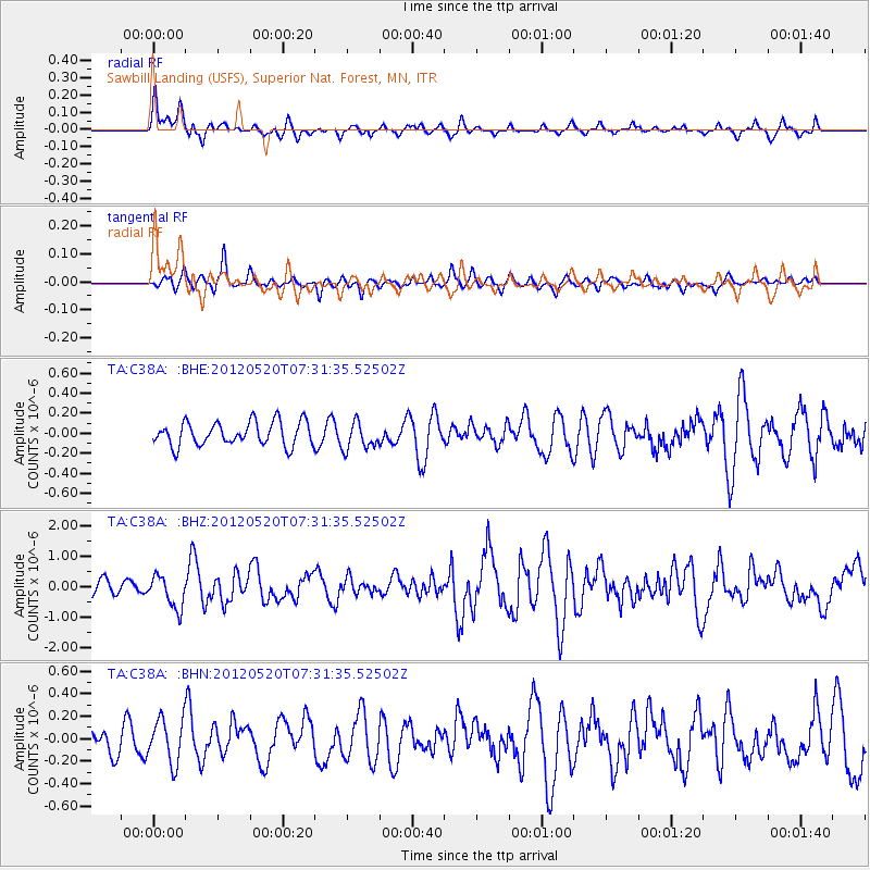
C38A Sawbill Landing (USFS), Superior Nat. Forest, MN, - Earthquake Result Viewer
*The percent match for this event was below the threshold and hence no stack was calculated.
| Earthquake location: |
Off East Coast Of Honshu, Japan |
| Earthquake latitude/longitude: |
39.5/143.2 |
| Earthquake time(UTC): |
2012/05/20 (141) 07:19:54 GMT |
| Earthquake Depth: |
11 km |
| Earthquake Magnitude: |
5.6 MB |
| Earthquake Catalog/Contributor: |
WHDF/NEIC |
|
| Network: |
TA USArray Transportable Network (new EarthScope stations) |
| Station: |
C38A Sawbill Landing (USFS), Superior Nat. Forest, MN, |
| Lat/Lon: |
47.72 N/91.27 W |
| Elevation: |
498 m |
|
| Distance: |
80.5 deg |
| Az: |
33.883 deg |
| Baz: |
320.331 deg |
| Ray Param: |
$rayparam |
*The percent match for this event was below the threshold and hence was not used in the summary stack. |
|
| Radial Match: |
73.06484 % |
| Radial Bump: |
400 |
| Transverse Match: |
51.351513 % |
| Transverse Bump: |
373 |
| SOD ConfigId: |
446234 |
| Insert Time: |
2012-08-25 18:28:38.901 +0000 |
| GWidth: |
2.5 |
| Max Bumps: |
400 |
| Tol: |
0.001 |
|
Signal To Noise
| Channel | StoN | STA | LTA |
| TA:C38A: :BHZ:20120520T07:31:35.52502Z | 2.9701505 | 5.3807605E-7 | 1.8116121E-7 |
| TA:C38A: :BHN:20120520T07:31:35.52502Z | 1.428595 | 1.9593037E-7 | 1.37149E-7 |
| TA:C38A: :BHE:20120520T07:31:35.52502Z | 1.157931 | 1.3724028E-7 | 1.1852199E-7 |
| Arrivals |
| Ps | |
| PpPs | |
| PsPs/PpSs | |


