You are here: Home > Network List > TA - USArray Transportable Network (new EarthScope stations) Stations List
> Station J37A Redenius Farm, Forest, IA, USA > Earthquake Result Viewer
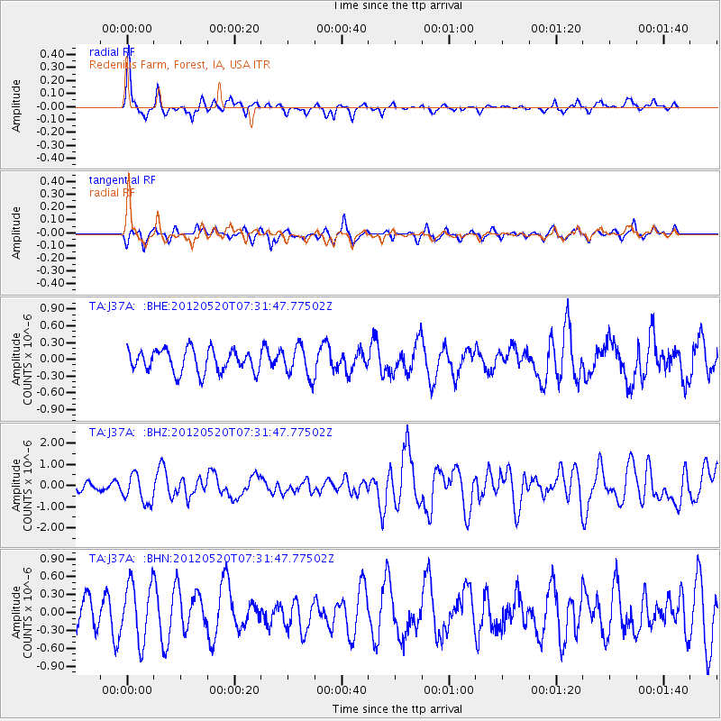
J37A Redenius Farm, Forest, IA, USA - Earthquake Result Viewer
*The percent match for this event was below the threshold and hence no stack was calculated.
| Earthquake location: |
Off East Coast Of Honshu, Japan |
| Earthquake latitude/longitude: |
39.5/143.2 |
| Earthquake time(UTC): |
2012/05/20 (141) 07:19:54 GMT |
| Earthquake Depth: |
11 km |
| Earthquake Magnitude: |
5.6 MB |
| Earthquake Catalog/Contributor: |
WHDF/NEIC |
|
| Network: |
TA USArray Transportable Network (new EarthScope stations) |
| Station: |
J37A Redenius Farm, Forest, IA, USA |
| Lat/Lon: |
43.31 N/93.55 W |
| Elevation: |
385 m |
|
| Distance: |
82.9 deg |
| Az: |
37.994 deg |
| Baz: |
319.304 deg |
| Ray Param: |
$rayparam |
*The percent match for this event was below the threshold and hence was not used in the summary stack. |
|
| Radial Match: |
72.51964 % |
| Radial Bump: |
352 |
| Transverse Match: |
61.227745 % |
| Transverse Bump: |
367 |
| SOD ConfigId: |
446234 |
| Insert Time: |
2012-08-25 18:29:03.655 +0000 |
| GWidth: |
2.5 |
| Max Bumps: |
400 |
| Tol: |
0.001 |
|
Signal To Noise
| Channel | StoN | STA | LTA |
| TA:J37A: :BHZ:20120520T07:31:47.77502Z | 2.4624014 | 6.7571165E-7 | 2.7441166E-7 |
| TA:J37A: :BHN:20120520T07:31:47.77502Z | 1.6113783 | 4.9782363E-7 | 3.0894276E-7 |
| TA:J37A: :BHE:20120520T07:31:47.77502Z | 1.3705157 | 2.7754746E-7 | 2.0251315E-7 |
| Arrivals |
| Ps | |
| PpPs | |
| PsPs/PpSs | |


