You are here: Home > Network List > TA - USArray Transportable Network (new EarthScope stations) Stations List
> Station TPFO Pinon Flats, CA, USA > Earthquake Result Viewer
TPFO Pinon Flats, CA, USA - Earthquake Result Viewer
| Earthquake location: |
Off East Coast Of Honshu, Japan |
| Earthquake latitude/longitude: |
39.5/143.2 |
| Earthquake time(UTC): |
2012/05/20 (141) 07:19:54 GMT |
| Earthquake Depth: |
11 km |
| Earthquake Magnitude: |
5.6 MB |
| Earthquake Catalog/Contributor: |
WHDF/NEIC |
|
| Network: |
TA USArray Transportable Network (new EarthScope stations) |
| Station: |
TPFO Pinon Flats, CA, USA |
| Lat/Lon: |
33.61 N/116.45 W |
| Elevation: |
1275 m |
|
| Distance: |
76.5 deg |
| Az: |
57.627 deg |
| Baz: |
308.514 deg |
| Ray Param: |
0.050973453 |
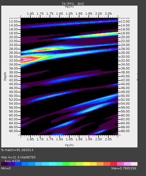
| Estimated Moho Depth: |
31.5 km |
| Estimated Crust Vp/Vs: |
1.63 |
| Assumed Crust Vp: |
6.264 km/s |
| Estimated Crust Vs: |
3.837 km/s |
| Estimated Crust Poisson's Ratio: |
0.20 |
|
| Radial Match: |
91.863014 % |
| Radial Bump: |
362 |
| Transverse Match: |
77.431786 % |
| Transverse Bump: |
316 |
| SOD ConfigId: |
446234 |
| Insert Time: |
2012-08-25 18:33:22.660 +0000 |
| GWidth: |
2.5 |
| Max Bumps: |
400 |
| Tol: |
0.001 |
|
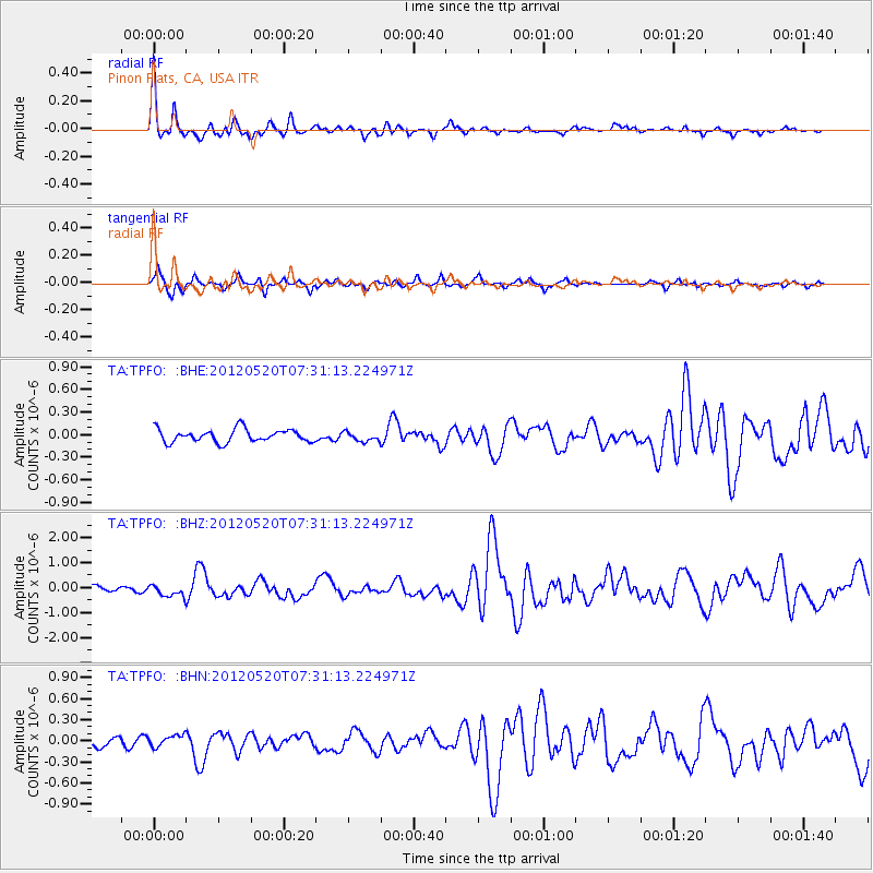
Signal To Noise
| Channel | StoN | STA | LTA |
| TA:TPFO: :BHZ:20120520T07:31:13.224971Z | 2.339805 | 2.3221706E-7 | 9.924633E-8 |
| TA:TPFO: :BHN:20120520T07:31:13.224971Z | 1.2421236 | 8.586268E-8 | 6.912571E-8 |
| TA:TPFO: :BHE:20120520T07:31:13.224971Z | 0.7282829 | 6.1731235E-8 | 8.476272E-8 |
| Arrivals |
| Ps | 3.3 SECOND |
| PpPs | 13 SECOND |
| PsPs/PpSs | 16 SECOND |


