You are here: Home > Network List > TA - USArray Transportable Network (new EarthScope stations) Stations List
> Station F38A Pierce - Schroeder Farm, Trego, WI, USA > Earthquake Result Viewer
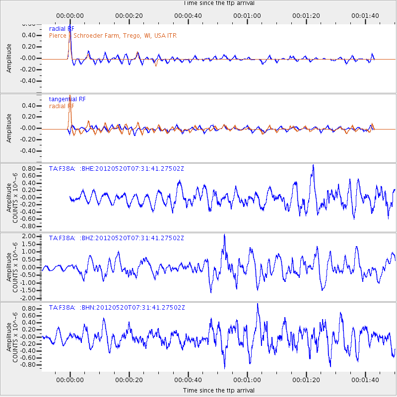
F38A Pierce - Schroeder Farm, Trego, WI, USA - Earthquake Result Viewer

| Earthquake location: |
Off East Coast Of Honshu, Japan |
| Earthquake latitude/longitude: |
39.5/143.2 |
| Earthquake time(UTC): |
2012/05/20 (141) 07:19:54 GMT |
| Earthquake Depth: |
11 km |
| Earthquake Magnitude: |
5.6 MB |
| Earthquake Catalog/Contributor: |
WHDF/NEIC |
|
| Network: |
TA USArray Transportable Network (new EarthScope stations) |
| Station: |
F38A Pierce - Schroeder Farm, Trego, WI, USA |
| Lat/Lon: |
45.96 N/91.88 W |
| Elevation: |
321 m |
|
| Distance: |
81.6 deg |
| Az: |
35.345 deg |
| Baz: |
320.119 deg |
| Ray Param: |
0.04746735 |
| Estimated Moho Depth: |
43.25 km |
| Estimated Crust Vp/Vs: |
1.89 |
| Assumed Crust Vp: |
6.571 km/s |
| Estimated Crust Vs: |
3.467 km/s |
| Estimated Crust Poisson's Ratio: |
0.31 |
|
| Radial Match: |
82.75893 % |
| Radial Bump: |
358 |
| Transverse Match: |
48.515316 % |
| Transverse Bump: |
400 |
| SOD ConfigId: |
446234 |
| Insert Time: |
2012-08-25 18:36:48.388 +0000 |
| GWidth: |
2.5 |
| Max Bumps: |
400 |
| Tol: |
0.001 |
|
Signal To Noise
| Channel | StoN | STA | LTA |
| TA:F38A: :BHZ:20120520T07:31:41.27502Z | 3.0709698 | 3.2179628E-7 | 1.0478653E-7 |
| TA:F38A: :BHN:20120520T07:31:41.27502Z | 0.91781044 | 1.0331997E-7 | 1.1257224E-7 |
| TA:F38A: :BHE:20120520T07:31:41.27502Z | 1.3737766 | 1.6011421E-7 | 1.165504E-7 |
| Arrivals |
| Ps | 6.0 SECOND |
| PpPs | 19 SECOND |
| PsPs/PpSs | 25 SECOND |


