You are here: Home > Network List > TA - USArray Transportable Network (new EarthScope stations) Stations List
> Station C40A Isle Royale National Park, MI, USA > Earthquake Result Viewer
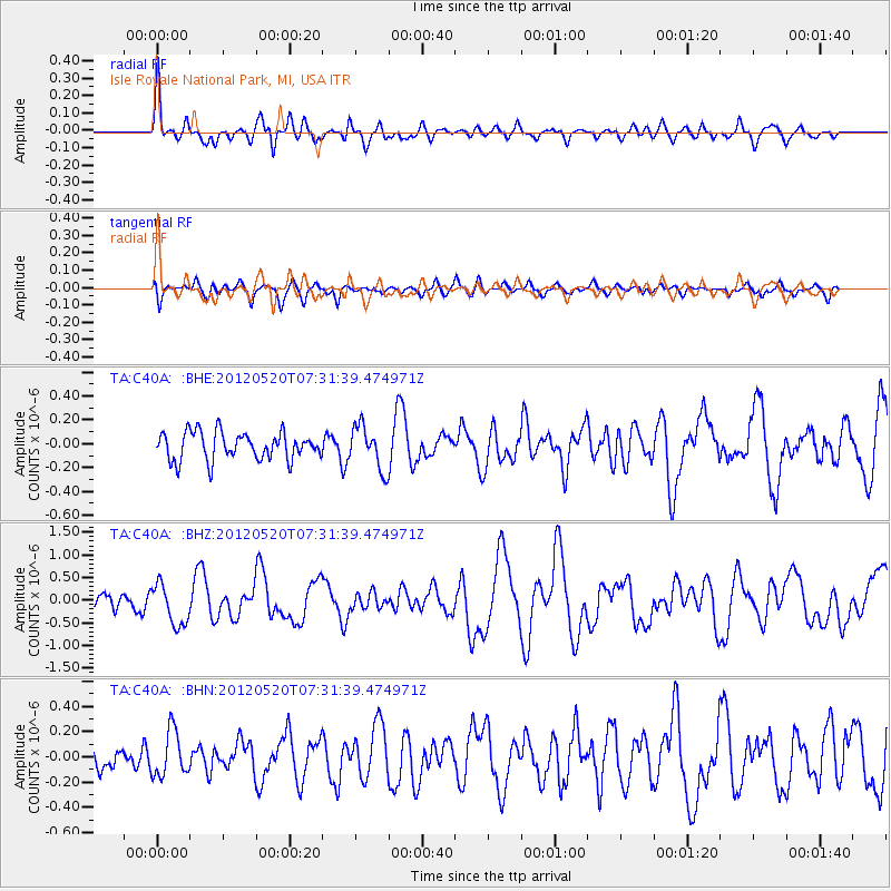
C40A Isle Royale National Park, MI, USA - Earthquake Result Viewer
*The percent match for this event was below the threshold and hence no stack was calculated.
| Earthquake location: |
Off East Coast Of Honshu, Japan |
| Earthquake latitude/longitude: |
39.5/143.2 |
| Earthquake time(UTC): |
2012/05/20 (141) 07:19:54 GMT |
| Earthquake Depth: |
11 km |
| Earthquake Magnitude: |
5.6 MB |
| Earthquake Catalog/Contributor: |
WHDF/NEIC |
|
| Network: |
TA USArray Transportable Network (new EarthScope stations) |
| Station: |
C40A Isle Royale National Park, MI, USA |
| Lat/Lon: |
47.92 N/89.15 W |
| Elevation: |
216 m |
|
| Distance: |
81.3 deg |
| Az: |
32.631 deg |
| Baz: |
321.701 deg |
| Ray Param: |
$rayparam |
*The percent match for this event was below the threshold and hence was not used in the summary stack. |
|
| Radial Match: |
76.89176 % |
| Radial Bump: |
388 |
| Transverse Match: |
57.26784 % |
| Transverse Bump: |
400 |
| SOD ConfigId: |
446234 |
| Insert Time: |
2012-08-25 18:38:30.128 +0000 |
| GWidth: |
2.5 |
| Max Bumps: |
400 |
| Tol: |
0.001 |
|
Signal To Noise
| Channel | StoN | STA | LTA |
| TA:C40A: :BHZ:20120520T07:31:39.474971Z | 2.6076052 | 4.5185232E-7 | 1.7328247E-7 |
| TA:C40A: :BHN:20120520T07:31:39.474971Z | 1.5379684 | 1.806262E-7 | 1.1744468E-7 |
| TA:C40A: :BHE:20120520T07:31:39.474971Z | 1.584931 | 1.8212377E-7 | 1.1490959E-7 |
| Arrivals |
| Ps | |
| PpPs | |
| PsPs/PpSs | |


