You are here: Home > Network List > UW - Pacific Northwest Regional Seismic Network Stations List
> Station MRBL Marblemount, WA, USA > Earthquake Result Viewer
MRBL Marblemount, WA, USA - Earthquake Result Viewer
| Earthquake location: |
Off East Coast Of Honshu, Japan |
| Earthquake latitude/longitude: |
39.5/143.2 |
| Earthquake time(UTC): |
2012/05/20 (141) 07:19:54 GMT |
| Earthquake Depth: |
11 km |
| Earthquake Magnitude: |
5.6 MB |
| Earthquake Catalog/Contributor: |
WHDF/NEIC |
|
| Network: |
UW Pacific Northwest Regional Seismic Network |
| Station: |
MRBL Marblemount, WA, USA |
| Lat/Lon: |
48.52 N/121.48 W |
| Elevation: |
75 m |
|
| Distance: |
64.8 deg |
| Az: |
47.053 deg |
| Baz: |
301.655 deg |
| Ray Param: |
0.058717698 |
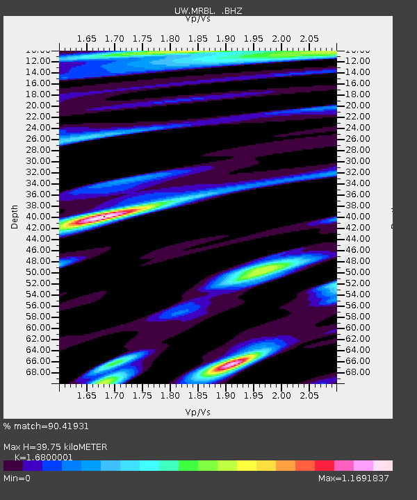
| Estimated Moho Depth: |
39.75 km |
| Estimated Crust Vp/Vs: |
1.68 |
| Assumed Crust Vp: |
6.566 km/s |
| Estimated Crust Vs: |
3.908 km/s |
| Estimated Crust Poisson's Ratio: |
0.23 |
|
| Radial Match: |
90.41931 % |
| Radial Bump: |
400 |
| Transverse Match: |
85.96274 % |
| Transverse Bump: |
400 |
| SOD ConfigId: |
446234 |
| Insert Time: |
2012-08-25 18:41:18.043 +0000 |
| GWidth: |
2.5 |
| Max Bumps: |
400 |
| Tol: |
0.001 |
|
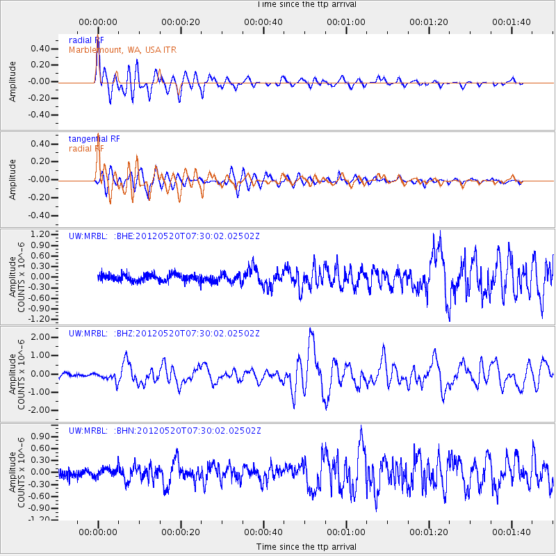
Signal To Noise
| Channel | StoN | STA | LTA |
| UW:MRBL: :BHZ:20120520T07:30:02.02502Z | 2.9422765 | 2.442187E-7 | 8.3003314E-8 |
| UW:MRBL: :BHN:20120520T07:30:02.02502Z | 1.4113696 | 1.1333063E-7 | 8.029834E-8 |
| UW:MRBL: :BHE:20120520T07:30:02.02502Z | 1.1866668 | 1.1634708E-7 | 9.8045284E-8 |
| Arrivals |
| Ps | 4.3 SECOND |
| PpPs | 15 SECOND |
| PsPs/PpSs | 20 SECOND |


