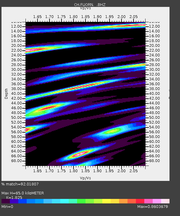
FUORN Ofenpass-Fuorn - Earthquake Result Viewer

Earthquake location: Off East Coast Of Honshu, Japan
Earthquake latitude/longitude: 39.6/143.2
Earthquake time(UTC): 2012/05/20 (141) 07:20:36 GMT
Earthquake Depth: 11 km
Earthquake Magnitude: 5.9 MB, 6.2 MS, 6.3 MW, 6.3 MW
Earthquake Catalog/Contributor: WHDF/NEIC
Network: CH Switzerland Seismological Network
Station: FUORN Ofenpass-Fuorn
Lat/Lon: 46.62 N/10.26 E
Elevation: 2333 m
Distance: 84.4 deg
Az: 329.512 deg
Baz: 34.634 deg
Ray Param: 0.045532394
Estimated Moho Depth: 65.0 km
Estimated Crust Vp/Vs: 1.83
Assumed Crust Vp: 6.35 km/s
Estimated Crust Vs: 3.479 km/s
Estimated Crust Poisson's Ratio: 0.29
Radial Match: 92.01807 %
Radial Bump: 400
Transverse Match: 86.532234 %
Transverse Bump: 400
SOD ConfigId: 446234
Insert Time: 2012-08-25 18:49:08.289 +0000
GWidth: 2.5
Max Bumps: 400
Tol: 0.001

Signal To Noise

ChannelStoNSTALTA
CH:FUORN: :BHZ:20120520T07:32:37.516973Z1.37965278.397856E-76.086934E-7
CH:FUORN: :BHN:20120520T07:32:37.500981Z0.76700512.0673603E-72.695367E-7
CH:FUORN: :BHE:20120520T07:32:37.516973Z1.40100152.6994283E-71.9267848E-7
Arrivals
Ps8.6 SECOND
PpPs28 SECOND
PsPs/PpSs37 SECOND