You are here: Home > Network List > TA - USArray Transportable Network (new EarthScope stations) Stations List
> Station Q37A Longview Farm, Lee's Summit, MO, USA > Earthquake Result Viewer
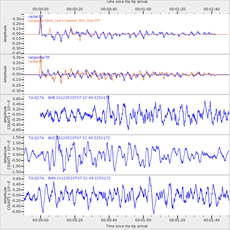
Q37A Longview Farm, Lee's Summit, MO, USA - Earthquake Result Viewer
| Earthquake location: |
Off East Coast Of Honshu, Japan |
| Earthquake latitude/longitude: |
39.6/143.2 |
| Earthquake time(UTC): |
2012/05/20 (141) 07:20:36 GMT |
| Earthquake Depth: |
11 km |
| Earthquake Magnitude: |
5.9 MB, 6.2 MS, 6.3 MW, 6.3 MW |
| Earthquake Catalog/Contributor: |
WHDF/NEIC |
|
| Network: |
TA USArray Transportable Network (new EarthScope stations) |
| Station: |
Q37A Longview Farm, Lee's Summit, MO, USA |
| Lat/Lon: |
38.88 N/94.45 W |
| Elevation: |
297 m |
|
| Distance: |
85.7 deg |
| Az: |
41.376 deg |
| Baz: |
319.168 deg |
| Ray Param: |
0.04455328 |
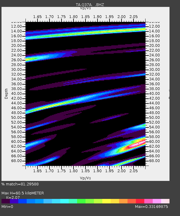
| Estimated Moho Depth: |
60.5 km |
| Estimated Crust Vp/Vs: |
2.07 |
| Assumed Crust Vp: |
6.498 km/s |
| Estimated Crust Vs: |
3.139 km/s |
| Estimated Crust Poisson's Ratio: |
0.35 |
|
| Radial Match: |
81.29588 % |
| Radial Bump: |
322 |
| Transverse Match: |
56.52646 % |
| Transverse Bump: |
400 |
| SOD ConfigId: |
446234 |
| Insert Time: |
2012-08-25 18:53:51.342 +0000 |
| GWidth: |
2.5 |
| Max Bumps: |
400 |
| Tol: |
0.001 |
|
Signal To Noise
| Channel | StoN | STA | LTA |
| TA:Q37A: :BHZ:20120520T07:32:44.325017Z | 0.64767396 | 2.6299082E-7 | 4.0605434E-7 |
| TA:Q37A: :BHN:20120520T07:32:44.325017Z | 2.376673 | 3.0981383E-7 | 1.3035611E-7 |
| TA:Q37A: :BHE:20120520T07:32:44.325017Z | 1.2388856 | 1.6810097E-7 | 1.3568724E-7 |
| Arrivals |
| Ps | 10 SECOND |
| PpPs | 28 SECOND |
| PsPs/PpSs | 38 SECOND |


