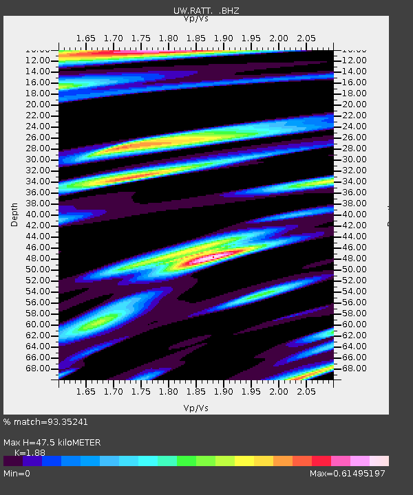
RATT Rattlesnake Lake, WA - Earthquake Result Viewer

Earthquake location: Off East Coast Of Honshu, Japan
Earthquake latitude/longitude: 39.6/143.2
Earthquake time(UTC): 2012/05/20 (141) 07:20:36 GMT
Earthquake Depth: 11 km
Earthquake Magnitude: 5.9 MB, 6.2 MS, 6.3 MW, 6.3 MW
Earthquake Catalog/Contributor: WHDF/NEIC
Network: UW Pacific Northwest Regional Seismic Network
Station: RATT Rattlesnake Lake, WA
Lat/Lon: 47.43 N/121.80 W
Elevation: 440 m
Distance: 65.1 deg
Az: 48.204 deg
Baz: 302.034 deg
Ray Param: 0.058471203
Estimated Moho Depth: 47.5 km
Estimated Crust Vp/Vs: 1.88
Assumed Crust Vp: 6.597 km/s
Estimated Crust Vs: 3.509 km/s
Estimated Crust Poisson's Ratio: 0.30
Radial Match: 93.35241 %
Radial Bump: 399
Transverse Match: 82.25675 %
Transverse Bump: 400
SOD ConfigId: 446234
Insert Time: 2012-08-25 18:59:01.672 +0000
GWidth: 2.5
Max Bumps: 400
Tol: 0.001

Signal To Noise

ChannelStoNSTALTA
UW:RATT: :BHZ:20120520T07:30:46.47498Z0.453033662.555954E-75.6418634E-7
UW:RATT: :BHN:20120520T07:30:46.47498Z1.57401142.442536E-71.5517907E-7
UW:RATT: :BHE:20120520T07:30:46.47498Z0.94055322.3632361E-72.5126022E-7
Arrivals
Ps6.6 SECOND
PpPs20 SECOND
PsPs/PpSs26 SECOND