You are here: Home > Network List > AK - Alaska Regional Network Stations List
> Station NOTK Noatak, AK, USA > Earthquake Result Viewer
NOTK Noatak, AK, USA - Earthquake Result Viewer
| Earthquake location: |
Kermadec Islands Region |
| Earthquake latitude/longitude: |
-27.6/-179.0 |
| Earthquake time(UTC): |
2014/05/14 (134) 01:51:34 GMT |
| Earthquake Depth: |
382 km |
| Earthquake Magnitude: |
5.4 MW |
| Earthquake Catalog/Contributor: |
ISC/ISC |
|
| Network: |
AK Alaska Regional Network |
| Station: |
NOTK Noatak, AK, USA |
| Lat/Lon: |
67.58 N/162.97 W |
| Elevation: |
24 m |
|
| Distance: |
95.6 deg |
| Az: |
6.092 deg |
| Baz: |
194.217 deg |
| Ray Param: |
0.040384408 |
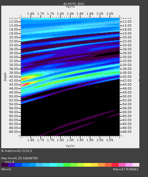
| Estimated Moho Depth: |
44.25 km |
| Estimated Crust Vp/Vs: |
1.60 |
| Assumed Crust Vp: |
6.276 km/s |
| Estimated Crust Vs: |
3.922 km/s |
| Estimated Crust Poisson's Ratio: |
0.18 |
|
| Radial Match: |
82.21513 % |
| Radial Bump: |
400 |
| Transverse Match: |
76.7853 % |
| Transverse Bump: |
400 |
| SOD ConfigId: |
3390531 |
| Insert Time: |
2019-04-11 20:51:13.597 +0000 |
| GWidth: |
2.5 |
| Max Bumps: |
400 |
| Tol: |
0.001 |
|

Signal To Noise
| Channel | StoN | STA | LTA |
| AK:NOTK: :BHZ:20140514T02:03:46.008008Z | 0.6068938 | 1.3708552E-7 | 2.2588058E-7 |
| AK:NOTK: :BHN:20140514T02:03:46.008008Z | 3.1498177 | 6.128362E-6 | 1.9456245E-6 |
| AK:NOTK: :BHE:20140514T02:03:46.008008Z | 0.8735305 | 5.2336163E-6 | 5.991338E-6 |
| Arrivals |
| Ps | 4.3 SECOND |
| PpPs | 18 SECOND |
| PsPs/PpSs | 22 SECOND |


