You are here: Home > Network List > UW - Pacific Northwest Regional Seismic Network Stations List
> Station LEBA Lebam, WA, USA > Earthquake Result Viewer
LEBA Lebam, WA, USA - Earthquake Result Viewer
*The percent match for this event was below the threshold and hence no stack was calculated.
| Earthquake location: |
Kermadec Islands Region |
| Earthquake latitude/longitude: |
-27.6/-179.0 |
| Earthquake time(UTC): |
2014/05/14 (134) 01:51:34 GMT |
| Earthquake Depth: |
382 km |
| Earthquake Magnitude: |
5.4 MW |
| Earthquake Catalog/Contributor: |
ISC/ISC |
|
| Network: |
UW Pacific Northwest Regional Seismic Network |
| Station: |
LEBA Lebam, WA, USA |
| Lat/Lon: |
46.55 N/123.56 W |
| Elevation: |
73 m |
|
| Distance: |
89.1 deg |
| Az: |
34.62 deg |
| Baz: |
226.947 deg |
| Ray Param: |
$rayparam |
*The percent match for this event was below the threshold and hence was not used in the summary stack. |
|
| Radial Match: |
57.89874 % |
| Radial Bump: |
400 |
| Transverse Match: |
67.01654 % |
| Transverse Bump: |
400 |
| SOD ConfigId: |
3390531 |
| Insert Time: |
2019-04-11 20:54:36.447 +0000 |
| GWidth: |
2.5 |
| Max Bumps: |
400 |
| Tol: |
0.001 |
|
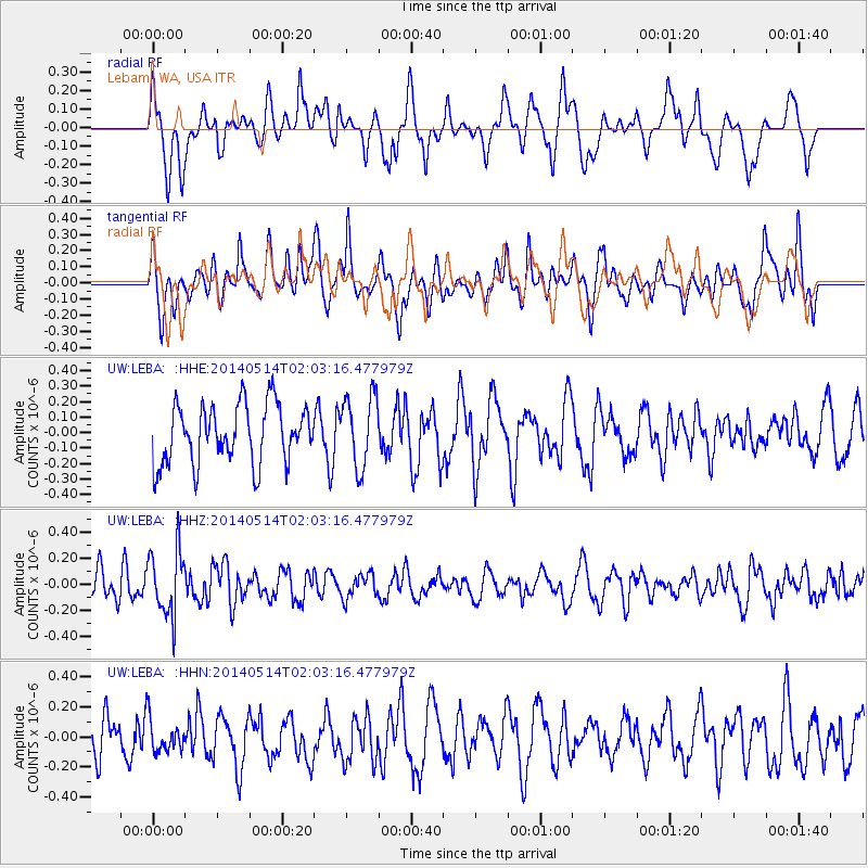
Signal To Noise
| Channel | StoN | STA | LTA |
| UW:LEBA: :HHZ:20140514T02:03:16.477979Z | 1.9640597 | 2.5107957E-7 | 1.2783704E-7 |
| UW:LEBA: :HHN:20140514T02:03:16.477979Z | 0.7637488 | 1.0895693E-7 | 1.426607E-7 |
| UW:LEBA: :HHE:20140514T02:03:16.477979Z | 1.2221706 | 2.3075944E-7 | 1.8881116E-7 |
| Arrivals |
| Ps | |
| PpPs | |
| PsPs/PpSs | |


