You are here: Home > Network List > UW - Pacific Northwest Regional Seismic Network Stations List
> Station PASS Maple Falls, WA, USA > Earthquake Result Viewer
PASS Maple Falls, WA, USA - Earthquake Result Viewer
| Earthquake location: |
Kermadec Islands Region |
| Earthquake latitude/longitude: |
-27.6/-179.0 |
| Earthquake time(UTC): |
2014/05/14 (134) 01:51:34 GMT |
| Earthquake Depth: |
382 km |
| Earthquake Magnitude: |
5.4 MW |
| Earthquake Catalog/Contributor: |
ISC/ISC |
|
| Network: |
UW Pacific Northwest Regional Seismic Network |
| Station: |
PASS Maple Falls, WA, USA |
| Lat/Lon: |
49.00 N/122.09 W |
| Elevation: |
174 m |
|
| Distance: |
91.5 deg |
| Az: |
33.485 deg |
| Baz: |
228.045 deg |
| Ray Param: |
0.041379366 |
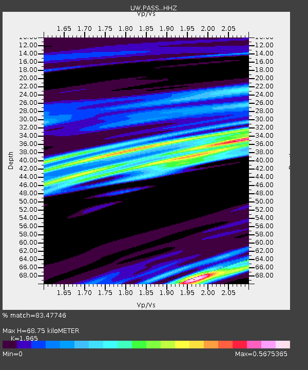
| Estimated Moho Depth: |
68.75 km |
| Estimated Crust Vp/Vs: |
1.97 |
| Assumed Crust Vp: |
6.566 km/s |
| Estimated Crust Vs: |
3.342 km/s |
| Estimated Crust Poisson's Ratio: |
0.33 |
|
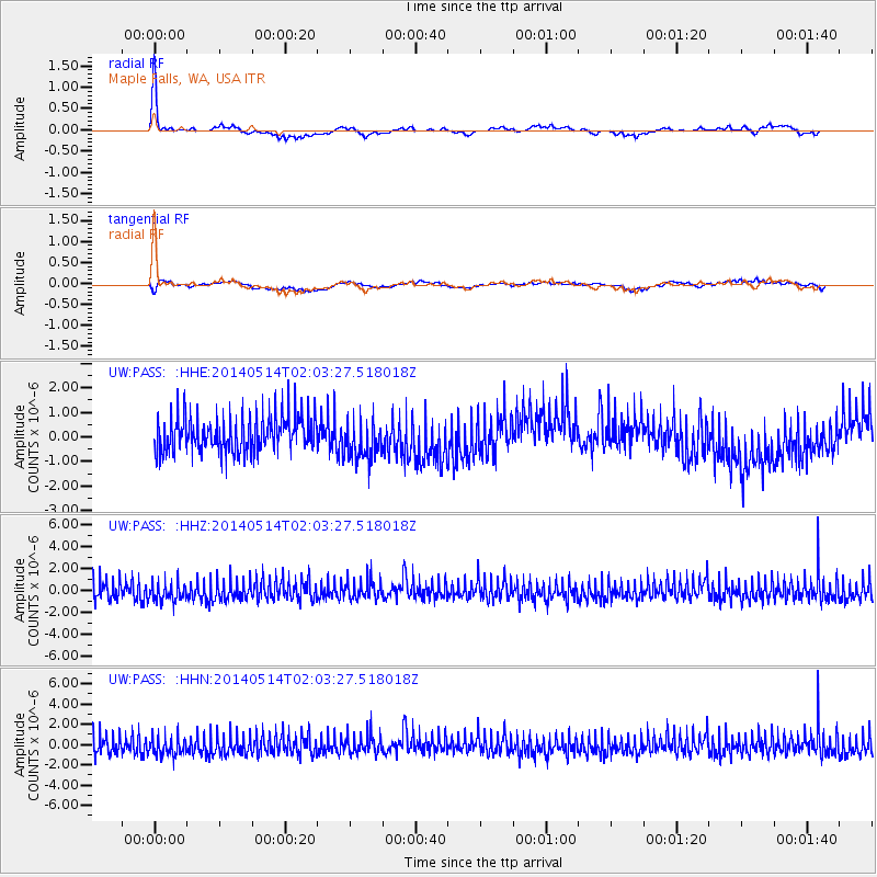
| Radial Match: |
83.47746 % |
| Radial Bump: |
275 |
| Transverse Match: |
54.399857 % |
| Transverse Bump: |
400 |
| SOD ConfigId: |
3390531 |
| Insert Time: |
2019-04-11 20:54:36.963 +0000 |
| GWidth: |
2.5 |
| Max Bumps: |
400 |
| Tol: |
0.001 |
|
Signal To Noise
| Channel | StoN | STA | LTA |
| UW:PASS: :HHZ:20140514T02:03:27.518018Z | 1.01189 | 8.7716916E-7 | 8.668621E-7 |
| UW:PASS: :HHN:20140514T02:03:27.518018Z | 1.038326 | 9.4883774E-7 | 9.1381486E-7 |
| UW:PASS: :HHE:20140514T02:03:27.518018Z | 1.1239638 | 8.306993E-7 | 7.390801E-7 |
| Arrivals |
| Ps | 10 SECOND |
| PpPs | 30 SECOND |
| PsPs/PpSs | 41 SECOND |


