You are here: Home > Network List > TA - USArray Transportable Network (new EarthScope stations) Stations List
> Station T38A Diamond, MO, USA > Earthquake Result Viewer
T38A Diamond, MO, USA - Earthquake Result Viewer
| Earthquake location: |
Bulgaria |
| Earthquake latitude/longitude: |
42.6/23.0 |
| Earthquake time(UTC): |
2012/05/22 (143) 00:00:32 GMT |
| Earthquake Depth: |
10 km |
| Earthquake Magnitude: |
5.7 MB, 5.3 MS, 5.6 MW, 5.5 MW |
| Earthquake Catalog/Contributor: |
WHDF/NEIC |
|
| Network: |
TA USArray Transportable Network (new EarthScope stations) |
| Station: |
T38A Diamond, MO, USA |
| Lat/Lon: |
37.04 N/94.29 W |
| Elevation: |
349 m |
|
| Distance: |
82.3 deg |
| Az: |
314.124 deg |
| Baz: |
41.443 deg |
| Ray Param: |
0.046998534 |
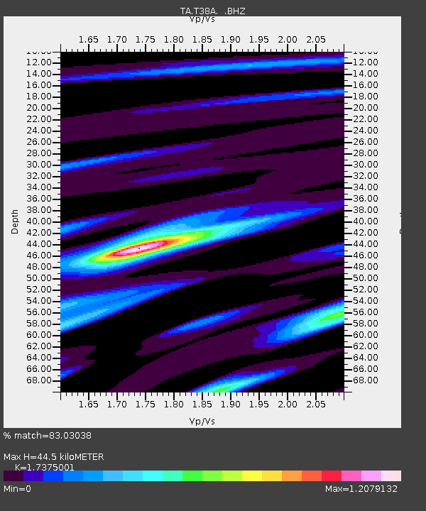
| Estimated Moho Depth: |
44.5 km |
| Estimated Crust Vp/Vs: |
1.74 |
| Assumed Crust Vp: |
6.53 km/s |
| Estimated Crust Vs: |
3.759 km/s |
| Estimated Crust Poisson's Ratio: |
0.25 |
|
| Radial Match: |
83.03038 % |
| Radial Bump: |
400 |
| Transverse Match: |
59.36156 % |
| Transverse Bump: |
400 |
| SOD ConfigId: |
446234 |
| Insert Time: |
2012-08-25 19:30:18.044 +0000 |
| GWidth: |
2.5 |
| Max Bumps: |
400 |
| Tol: |
0.001 |
|

Signal To Noise
| Channel | StoN | STA | LTA |
| TA:T38A: :BHZ:20120522T00:12:22.850017Z | 9.143625 | 6.610371E-7 | 7.229486E-8 |
| TA:T38A: :BHN:20120522T00:12:22.850017Z | 1.8775266 | 2.2024547E-7 | 1.1730618E-7 |
| TA:T38A: :BHE:20120522T00:12:22.850017Z | 1.9025381 | 1.56768E-7 | 8.23994E-8 |
| Arrivals |
| Ps | 5.2 SECOND |
| PpPs | 18 SECOND |
| PsPs/PpSs | 23 SECOND |


