You are here: Home > Network List > TA - USArray Transportable Network (new EarthScope stations) Stations List
> Station W54A Cherokee Point, Campobello, SC, USA > Earthquake Result Viewer
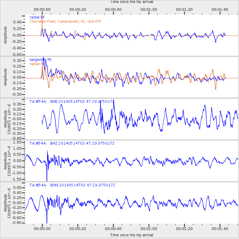
W54A Cherokee Point, Campobello, SC, USA - Earthquake Result Viewer
*The percent match for this event was below the threshold and hence no stack was calculated.
| Earthquake location: |
Jujuy Province, Argentina |
| Earthquake latitude/longitude: |
-22.7/-66.6 |
| Earthquake time(UTC): |
2014/05/14 (134) 03:38:22 GMT |
| Earthquake Depth: |
223 km |
| Earthquake Magnitude: |
5.6 MW |
| Earthquake Catalog/Contributor: |
ISC/ISC |
|
| Network: |
TA USArray Transportable Network (new EarthScope stations) |
| Station: |
W54A Cherokee Point, Campobello, SC, USA |
| Lat/Lon: |
35.09 N/82.19 W |
| Elevation: |
272 m |
|
| Distance: |
59.4 deg |
| Az: |
345.148 deg |
| Baz: |
163.229 deg |
| Ray Param: |
$rayparam |
*The percent match for this event was below the threshold and hence was not used in the summary stack. |
|
| Radial Match: |
60.261528 % |
| Radial Bump: |
400 |
| Transverse Match: |
67.819565 % |
| Transverse Bump: |
400 |
| SOD ConfigId: |
3390531 |
| Insert Time: |
2019-04-11 21:01:13.284 +0000 |
| GWidth: |
2.5 |
| Max Bumps: |
400 |
| Tol: |
0.001 |
|
Signal To Noise
| Channel | StoN | STA | LTA |
| TA:W54A: :BHZ:20140514T03:47:29.975017Z | 1.5321015 | 3.6440437E-7 | 2.3784611E-7 |
| TA:W54A: :BHN:20140514T03:47:29.975017Z | 1.8254776 | 2.425219E-7 | 1.3285396E-7 |
| TA:W54A: :BHE:20140514T03:47:29.975017Z | 0.8828111 | 1.1950956E-7 | 1.3537388E-7 |
| Arrivals |
| Ps | |
| PpPs | |
| PsPs/PpSs | |


