You are here: Home > Network List > G - GEOSCOPE Stations List
> Station PPTF Pamatai - Papeete - Tahiti island - French Polynesia, France > Earthquake Result Viewer
PPTF Pamatai - Papeete - Tahiti island - French Polynesia, France - Earthquake Result Viewer

| Earthquake location: |
Santa Cruz Islands |
| Earthquake latitude/longitude: |
-11.5/166.0 |
| Earthquake time(UTC): |
2009/10/07 (280) 22:29:18 GMT |
| Earthquake Depth: |
35 km |
| Earthquake Magnitude: |
5.5 MB |
| Earthquake Catalog/Contributor: |
WHDF/NEIC |
|
| Network: |
G GEOSCOPE |
| Station: |
PPTF Pamatai - Papeete - Tahiti island - French Polynesia, France |
| Lat/Lon: |
17.59 S/149.57 W |
| Elevation: |
705 m |
|
| Distance: |
43.3 deg |
| Az: |
103.427 deg |
| Baz: |
271.776 deg |
| Ray Param: |
0.07254963 |
| Estimated Moho Depth: |
48.0 km |
| Estimated Crust Vp/Vs: |
2.09 |
| Assumed Crust Vp: |
4.24 km/s |
| Estimated Crust Vs: |
2.034 km/s |
| Estimated Crust Poisson's Ratio: |
0.35 |
|
| Radial Match: |
84.54619 % |
| Radial Bump: |
360 |
| Transverse Match: |
51.659733 % |
| Transverse Bump: |
272 |
| SOD ConfigId: |
2622 |
| Insert Time: |
2010-02-26 23:43:18.487 +0000 |
| GWidth: |
2.5 |
| Max Bumps: |
400 |
| Tol: |
0.001 |
|
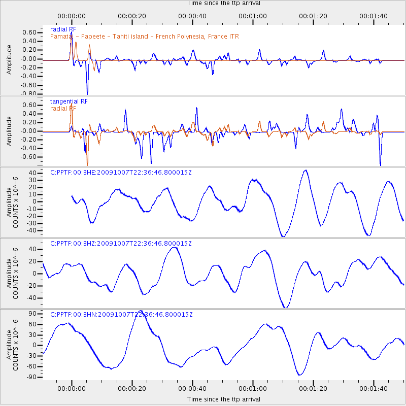
Signal To Noise
| Channel | StoN | STA | LTA |
| G:PPTF:00:BHZ:20091007T22:36:46.800015Z | 0.8360041 | 1.2598112E-5 | 1.5069439E-5 |
| G:PPTF:00:BHN:20091007T22:36:46.800015Z | 2.3097203 | 5.786598E-5 | 2.5053243E-5 |
| G:PPTF:00:BHE:20091007T22:36:46.800015Z | 1.1215802 | 1.3426931E-5 | 1.19714405E-5 |
| Arrivals |
| Ps | 13 SECOND |
| PpPs | 34 SECOND |
| PsPs/PpSs | 47 SECOND |


