You are here: Home > Network List > CI - Caltech Regional Seismic Network Stations List
> Station LGU LGU, Camarillo, CA, USA > Earthquake Result Viewer
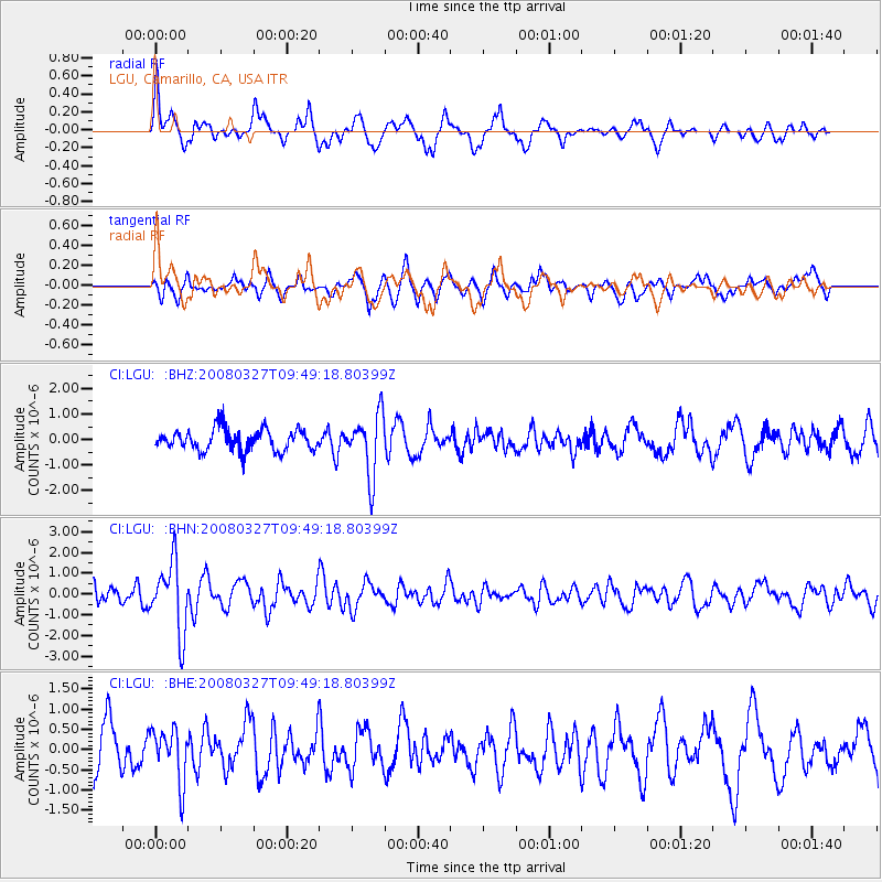
LGU LGU, Camarillo, CA, USA - Earthquake Result Viewer
*The percent match for this event was below the threshold and hence no stack was calculated.
| Earthquake location: |
North Of Honduras |
| Earthquake latitude/longitude: |
17.2/-84.8 |
| Earthquake time(UTC): |
2008/03/27 (087) 09:42:57 GMT |
| Earthquake Depth: |
10 km |
| Earthquake Magnitude: |
5.6 MW, 5.1 MS, 5.4 MB, 5.6 MW |
| Earthquake Catalog/Contributor: |
WHDF/NEIC |
|
| Network: |
CI Caltech Regional Seismic Network |
| Station: |
LGU LGU, Camarillo, CA, USA |
| Lat/Lon: |
34.11 N/119.07 W |
| Elevation: |
416 m |
|
| Distance: |
34.9 deg |
| Az: |
305.419 deg |
| Baz: |
110.147 deg |
| Ray Param: |
$rayparam |
*The percent match for this event was below the threshold and hence was not used in the summary stack. |
|
| Radial Match: |
65.78223 % |
| Radial Bump: |
400 |
| Transverse Match: |
44.61695 % |
| Transverse Bump: |
400 |
| SOD ConfigId: |
2504 |
| Insert Time: |
2010-02-25 20:21:55.855 +0000 |
| GWidth: |
2.5 |
| Max Bumps: |
400 |
| Tol: |
0.001 |
|
Signal To Noise
| Channel | StoN | STA | LTA |
| CI:LGU: :BHN:20080327T09:49:18.80399Z | 5.6355333 | 1.6680101E-6 | 2.9598087E-7 |
| CI:LGU: :BHE:20080327T09:49:18.80399Z | 0.99940735 | 6.528302E-7 | 6.532173E-7 |
| CI:LGU: :BHZ:20080327T09:49:18.80399Z | 2.8201299 | 1.1835625E-6 | 4.1968372E-7 |
| Arrivals |
| Ps | |
| PpPs | |
| PsPs/PpSs | |


