You are here: Home > Network List > TA - USArray Transportable Network (new EarthScope stations) Stations List
> Station O03D Paynes Creek, CA, USA > Earthquake Result Viewer
O03D Paynes Creek, CA, USA - Earthquake Result Viewer
| Earthquake location: |
Hokkaido, Japan Region |
| Earthquake latitude/longitude: |
41.3/142.1 |
| Earthquake time(UTC): |
2012/05/23 (144) 15:02:25 GMT |
| Earthquake Depth: |
46 km |
| Earthquake Magnitude: |
6.2 MB, 5.5 MS, 5.9 MW, 6.0 MW |
| Earthquake Catalog/Contributor: |
WHDF/NEIC |
|
| Network: |
TA USArray Transportable Network (new EarthScope stations) |
| Station: |
O03D Paynes Creek, CA, USA |
| Lat/Lon: |
40.29 N/121.80 W |
| Elevation: |
968 m |
|
| Distance: |
68.7 deg |
| Az: |
54.687 deg |
| Baz: |
306.543 deg |
| Ray Param: |
0.056013163 |
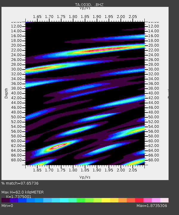
| Estimated Moho Depth: |
62.0 km |
| Estimated Crust Vp/Vs: |
1.74 |
| Assumed Crust Vp: |
6.566 km/s |
| Estimated Crust Vs: |
3.779 km/s |
| Estimated Crust Poisson's Ratio: |
0.25 |
|
| Radial Match: |
87.65736 % |
| Radial Bump: |
400 |
| Transverse Match: |
86.9425 % |
| Transverse Bump: |
400 |
| SOD ConfigId: |
446234 |
| Insert Time: |
2012-08-25 20:19:58.362 +0000 |
| GWidth: |
2.5 |
| Max Bumps: |
400 |
| Tol: |
0.001 |
|
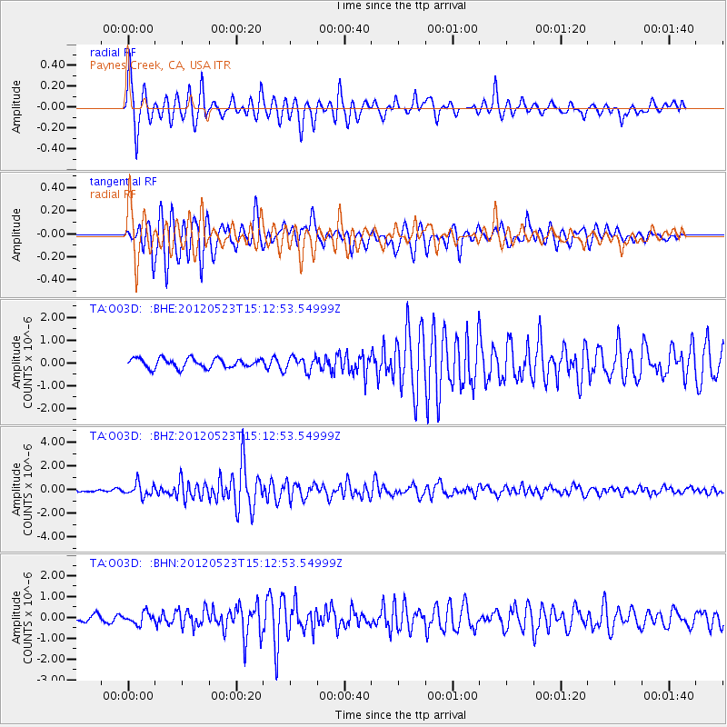
Signal To Noise
| Channel | StoN | STA | LTA |
| TA:O03D: :BHZ:20120523T15:12:53.54999Z | 3.8056817 | 5.4085797E-7 | 1.4211855E-7 |
| TA:O03D: :BHN:20120523T15:12:53.54999Z | 1.735019 | 2.6676489E-7 | 1.5375329E-7 |
| TA:O03D: :BHE:20120523T15:12:53.54999Z | 1.4824147 | 3.0649898E-7 | 2.0675655E-7 |
| Arrivals |
| Ps | 7.3 SECOND |
| PpPs | 25 SECOND |
| PsPs/PpSs | 32 SECOND |


