You are here: Home > Network List > TA - USArray Transportable Network (new EarthScope stations) Stations List
> Station E33A Westby DABS, Erhard, MN, USA > Earthquake Result Viewer
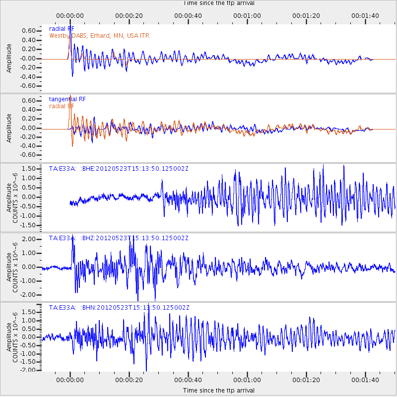
E33A Westby DABS, Erhard, MN, USA - Earthquake Result Viewer

| Earthquake location: |
Hokkaido, Japan Region |
| Earthquake latitude/longitude: |
41.3/142.1 |
| Earthquake time(UTC): |
2012/05/23 (144) 15:02:25 GMT |
| Earthquake Depth: |
46 km |
| Earthquake Magnitude: |
6.2 MB, 5.5 MS, 5.9 MW, 6.0 MW |
| Earthquake Catalog/Contributor: |
WHDF/NEIC |
|
| Network: |
TA USArray Transportable Network (new EarthScope stations) |
| Station: |
E33A Westby DABS, Erhard, MN, USA |
| Lat/Lon: |
46.50 N/96.01 W |
| Elevation: |
428 m |
|
| Distance: |
78.4 deg |
| Az: |
36.765 deg |
| Baz: |
319.268 deg |
| Ray Param: |
0.04957651 |
| Estimated Moho Depth: |
35.25 km |
| Estimated Crust Vp/Vs: |
1.80 |
| Assumed Crust Vp: |
6.498 km/s |
| Estimated Crust Vs: |
3.615 km/s |
| Estimated Crust Poisson's Ratio: |
0.28 |
|
| Radial Match: |
87.257034 % |
| Radial Bump: |
400 |
| Transverse Match: |
68.24863 % |
| Transverse Bump: |
400 |
| SOD ConfigId: |
446234 |
| Insert Time: |
2012-08-25 20:20:40.986 +0000 |
| GWidth: |
2.5 |
| Max Bumps: |
400 |
| Tol: |
0.001 |
|
Signal To Noise
| Channel | StoN | STA | LTA |
| TA:E33A: :BHZ:20120523T15:13:50.125002Z | 13.801282 | 8.677738E-7 | 6.287632E-8 |
| TA:E33A: :BHN:20120523T15:13:50.125002Z | 4.3274574 | 4.1210907E-7 | 9.523122E-8 |
| TA:E33A: :BHE:20120523T15:13:50.125002Z | 2.3857214 | 3.3117024E-7 | 1.3881345E-7 |
| Arrivals |
| Ps | 4.5 SECOND |
| PpPs | 15 SECOND |
| PsPs/PpSs | 19 SECOND |


