You are here: Home > Network List > TA - USArray Transportable Network (new EarthScope stations) Stations List
> Station H31A Wolsey, SD, USA > Earthquake Result Viewer
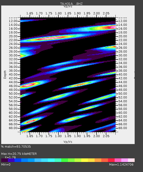
H31A Wolsey, SD, USA - Earthquake Result Viewer
| Earthquake location: |
Hokkaido, Japan Region |
| Earthquake latitude/longitude: |
41.3/142.1 |
| Earthquake time(UTC): |
2012/05/23 (144) 15:02:25 GMT |
| Earthquake Depth: |
46 km |
| Earthquake Magnitude: |
6.2 MB, 5.5 MS, 5.9 MW, 6.0 MW |
| Earthquake Catalog/Contributor: |
WHDF/NEIC |
|
| Network: |
TA USArray Transportable Network (new EarthScope stations) |
| Station: |
H31A Wolsey, SD, USA |
| Lat/Lon: |
44.48 N/98.48 W |
| Elevation: |
415 m |
|
| Distance: |
78.8 deg |
| Az: |
39.46 deg |
| Baz: |
318.043 deg |
| Ray Param: |
0.049325936 |
| Estimated Moho Depth: |
20.75 km |
| Estimated Crust Vp/Vs: |
1.76 |
| Assumed Crust Vp: |
6.53 km/s |
| Estimated Crust Vs: |
3.71 km/s |
| Estimated Crust Poisson's Ratio: |
0.26 |
|
| Radial Match: |
93.70535 % |
| Radial Bump: |
400 |
| Transverse Match: |
80.00345 % |
| Transverse Bump: |
400 |
| SOD ConfigId: |
446234 |
| Insert Time: |
2012-08-25 20:20:53.429 +0000 |
| GWidth: |
2.5 |
| Max Bumps: |
400 |
| Tol: |
0.001 |
|

Signal To Noise
| Channel | StoN | STA | LTA |
| TA:H31A: :BHZ:20120523T15:13:52.17499Z | 4.0636644 | 8.569785E-7 | 2.1088809E-7 |
| TA:H31A: :BHN:20120523T15:13:52.17499Z | 2.4600544 | 4.619686E-7 | 1.8778796E-7 |
| TA:H31A: :BHE:20120523T15:13:52.17499Z | 2.3337355 | 5.258411E-7 | 2.2532164E-7 |
| Arrivals |
| Ps | 2.5 SECOND |
| PpPs | 8.5 SECOND |
| PsPs/PpSs | 11 SECOND |


