You are here: Home > Network List > TA - USArray Transportable Network (new EarthScope stations) Stations List
> Station SUSD Miller, SD, USA > Earthquake Result Viewer
SUSD Miller, SD, USA - Earthquake Result Viewer
| Earthquake location: |
Hokkaido, Japan Region |
| Earthquake latitude/longitude: |
41.3/142.1 |
| Earthquake time(UTC): |
2012/05/23 (144) 15:02:25 GMT |
| Earthquake Depth: |
46 km |
| Earthquake Magnitude: |
6.2 MB, 5.5 MS, 5.9 MW, 6.0 MW |
| Earthquake Catalog/Contributor: |
WHDF/NEIC |
|
| Network: |
TA USArray Transportable Network (new EarthScope stations) |
| Station: |
SUSD Miller, SD, USA |
| Lat/Lon: |
44.44 N/98.96 W |
| Elevation: |
520 m |
|
| Distance: |
78.6 deg |
| Az: |
39.744 deg |
| Baz: |
317.765 deg |
| Ray Param: |
0.049462542 |
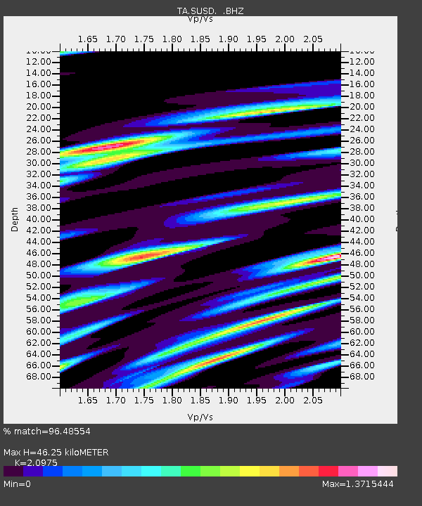
| Estimated Moho Depth: |
46.25 km |
| Estimated Crust Vp/Vs: |
2.10 |
| Assumed Crust Vp: |
6.53 km/s |
| Estimated Crust Vs: |
3.113 km/s |
| Estimated Crust Poisson's Ratio: |
0.35 |
|
| Radial Match: |
96.48554 % |
| Radial Bump: |
367 |
| Transverse Match: |
92.751625 % |
| Transverse Bump: |
400 |
| SOD ConfigId: |
446234 |
| Insert Time: |
2012-08-25 20:21:05.526 +0000 |
| GWidth: |
2.5 |
| Max Bumps: |
400 |
| Tol: |
0.001 |
|

Signal To Noise
| Channel | StoN | STA | LTA |
| TA:SUSD: :BHZ:20120523T15:13:51.04999Z | 11.085757 | 1.0093445E-6 | 9.104877E-8 |
| TA:SUSD: :BHN:20120523T15:13:51.04999Z | 4.7484193 | 6.0014145E-7 | 1.2638763E-7 |
| TA:SUSD: :BHE:20120523T15:13:51.04999Z | 6.1468 | 6.869334E-7 | 1.1175463E-7 |
| Arrivals |
| Ps | 8.0 SECOND |
| PpPs | 21 SECOND |
| PsPs/PpSs | 29 SECOND |


