You are here: Home > Network List > TA - USArray Transportable Network (new EarthScope stations) Stations List
> Station G32A Webster, SD, USA > Earthquake Result Viewer
G32A Webster, SD, USA - Earthquake Result Viewer

| Earthquake location: |
Hokkaido, Japan Region |
| Earthquake latitude/longitude: |
41.3/142.1 |
| Earthquake time(UTC): |
2012/05/23 (144) 15:02:25 GMT |
| Earthquake Depth: |
46 km |
| Earthquake Magnitude: |
6.2 MB, 5.5 MS, 5.9 MW, 6.0 MW |
| Earthquake Catalog/Contributor: |
WHDF/NEIC |
|
| Network: |
TA USArray Transportable Network (new EarthScope stations) |
| Station: |
G32A Webster, SD, USA |
| Lat/Lon: |
45.26 N/97.50 W |
| Elevation: |
566 m |
|
| Distance: |
78.7 deg |
| Az: |
38.404 deg |
| Baz: |
318.524 deg |
| Ray Param: |
0.049404528 |
| Estimated Moho Depth: |
25.5 km |
| Estimated Crust Vp/Vs: |
2.04 |
| Assumed Crust Vp: |
6.552 km/s |
| Estimated Crust Vs: |
3.22 km/s |
| Estimated Crust Poisson's Ratio: |
0.34 |
|
| Radial Match: |
83.6394 % |
| Radial Bump: |
400 |
| Transverse Match: |
74.1991 % |
| Transverse Bump: |
362 |
| SOD ConfigId: |
446234 |
| Insert Time: |
2012-08-25 20:22:06.211 +0000 |
| GWidth: |
2.5 |
| Max Bumps: |
400 |
| Tol: |
0.001 |
|
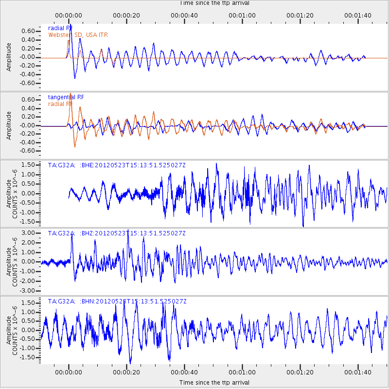
Signal To Noise
| Channel | StoN | STA | LTA |
| TA:G32A: :BHZ:20120523T15:13:51.525027Z | 6.991023 | 9.987853E-7 | 1.4286682E-7 |
| TA:G32A: :BHN:20120523T15:13:51.525027Z | 1.4846338 | 4.8735586E-7 | 3.2826674E-7 |
| TA:G32A: :BHE:20120523T15:13:51.525027Z | 1.9798809 | 5.241247E-7 | 2.6472537E-7 |
| Arrivals |
| Ps | 4.1 SECOND |
| PpPs | 12 SECOND |
| PsPs/PpSs | 16 SECOND |


