You are here: Home > Network List > TA - USArray Transportable Network (new EarthScope stations) Stations List
> Station M54A Oil Creek State Park, Oil City, PA, USA > Earthquake Result Viewer
M54A Oil Creek State Park, Oil City, PA, USA - Earthquake Result Viewer
| Earthquake location: |
Hokkaido, Japan Region |
| Earthquake latitude/longitude: |
41.3/142.1 |
| Earthquake time(UTC): |
2012/05/23 (144) 15:02:25 GMT |
| Earthquake Depth: |
46 km |
| Earthquake Magnitude: |
6.2 MB, 5.5 MS, 5.9 MW, 6.0 MW |
| Earthquake Catalog/Contributor: |
WHDF/NEIC |
|
| Network: |
TA USArray Transportable Network (new EarthScope stations) |
| Station: |
M54A Oil Creek State Park, Oil City, PA, USA |
| Lat/Lon: |
41.51 N/79.66 W |
| Elevation: |
488 m |
|
| Distance: |
89.3 deg |
| Az: |
30.009 deg |
| Baz: |
329.904 deg |
| Ray Param: |
0.041888017 |
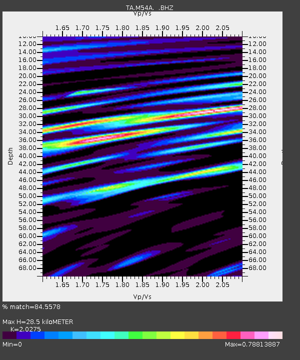
| Estimated Moho Depth: |
28.5 km |
| Estimated Crust Vp/Vs: |
2.03 |
| Assumed Crust Vp: |
6.121 km/s |
| Estimated Crust Vs: |
3.019 km/s |
| Estimated Crust Poisson's Ratio: |
0.34 |
|
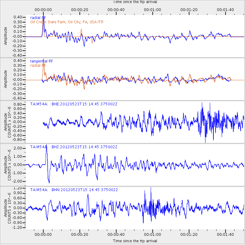
| Radial Match: |
84.5578 % |
| Radial Bump: |
400 |
| Transverse Match: |
67.30815 % |
| Transverse Bump: |
400 |
| SOD ConfigId: |
446234 |
| Insert Time: |
2012-08-25 20:24:54.578 +0000 |
| GWidth: |
2.5 |
| Max Bumps: |
400 |
| Tol: |
0.001 |
|
Signal To Noise
| Channel | StoN | STA | LTA |
| TA:M54A: :BHZ:20120523T15:14:45.375002Z | 8.058361 | 1.0564463E-6 | 1.310994E-7 |
| TA:M54A: :BHN:20120523T15:14:45.375002Z | 4.8203235 | 3.101004E-7 | 6.4331864E-8 |
| TA:M54A: :BHE:20120523T15:14:45.375002Z | 2.0169604 | 2.1192957E-7 | 1.0507375E-7 |
| Arrivals |
| Ps | 4.9 SECOND |
| PpPs | 14 SECOND |
| PsPs/PpSs | 19 SECOND |


