You are here: Home > Network List > TA - USArray Transportable Network (new EarthScope stations) Stations List
> Station P38A Dawn, MO, USA > Earthquake Result Viewer
P38A Dawn, MO, USA - Earthquake Result Viewer

| Earthquake location: |
Hokkaido, Japan Region |
| Earthquake latitude/longitude: |
41.3/142.1 |
| Earthquake time(UTC): |
2012/05/23 (144) 15:02:25 GMT |
| Earthquake Depth: |
46 km |
| Earthquake Magnitude: |
6.2 MB, 5.5 MS, 5.9 MW, 6.0 MW |
| Earthquake Catalog/Contributor: |
WHDF/NEIC |
|
| Network: |
TA USArray Transportable Network (new EarthScope stations) |
| Station: |
P38A Dawn, MO, USA |
| Lat/Lon: |
39.62 N/93.53 W |
| Elevation: |
248 m |
|
| Distance: |
84.9 deg |
| Az: |
39.787 deg |
| Baz: |
321.394 deg |
| Ray Param: |
0.04509915 |
| Estimated Moho Depth: |
24.25 km |
| Estimated Crust Vp/Vs: |
2.09 |
| Assumed Crust Vp: |
6.498 km/s |
| Estimated Crust Vs: |
3.109 km/s |
| Estimated Crust Poisson's Ratio: |
0.35 |
|
| Radial Match: |
90.22788 % |
| Radial Bump: |
400 |
| Transverse Match: |
67.784485 % |
| Transverse Bump: |
400 |
| SOD ConfigId: |
446234 |
| Insert Time: |
2012-08-25 20:26:12.144 +0000 |
| GWidth: |
2.5 |
| Max Bumps: |
400 |
| Tol: |
0.001 |
|
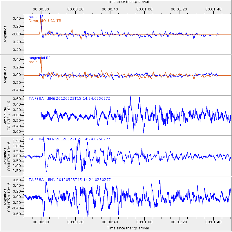
Signal To Noise
| Channel | StoN | STA | LTA |
| TA:P38A: :BHZ:20120523T15:14:24.025027Z | 13.820399 | 8.8916397E-7 | 6.4337065E-8 |
| TA:P38A: :BHN:20120523T15:14:24.025027Z | 3.589914 | 2.9754088E-7 | 8.288245E-8 |
| TA:P38A: :BHE:20120523T15:14:24.025027Z | 2.1236205 | 1.8538196E-7 | 8.7295234E-8 |
| Arrivals |
| Ps | 4.2 SECOND |
| PpPs | 11 SECOND |
| PsPs/PpSs | 15 SECOND |


