You are here: Home > Network List > TA - USArray Transportable Network (new EarthScope stations) Stations List
> Station S39A Bolivar, MO, USA > Earthquake Result Viewer
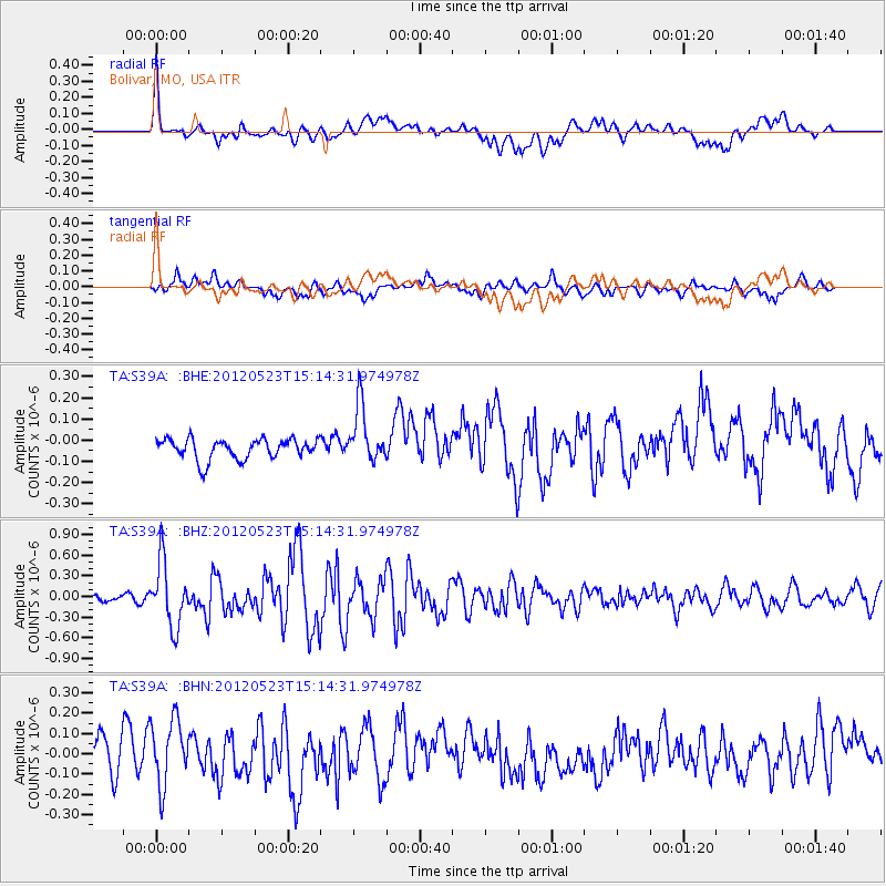
S39A Bolivar, MO, USA - Earthquake Result Viewer
*The percent match for this event was below the threshold and hence no stack was calculated.
| Earthquake location: |
Hokkaido, Japan Region |
| Earthquake latitude/longitude: |
41.3/142.1 |
| Earthquake time(UTC): |
2012/05/23 (144) 15:02:25 GMT |
| Earthquake Depth: |
46 km |
| Earthquake Magnitude: |
6.2 MB, 5.5 MS, 5.9 MW, 6.0 MW |
| Earthquake Catalog/Contributor: |
WHDF/NEIC |
|
| Network: |
TA USArray Transportable Network (new EarthScope stations) |
| Station: |
S39A Bolivar, MO, USA |
| Lat/Lon: |
37.69 N/93.32 W |
| Elevation: |
331 m |
|
| Distance: |
86.5 deg |
| Az: |
40.864 deg |
| Baz: |
321.605 deg |
| Ray Param: |
$rayparam |
*The percent match for this event was below the threshold and hence was not used in the summary stack. |
|
| Radial Match: |
73.81389 % |
| Radial Bump: |
400 |
| Transverse Match: |
59.332024 % |
| Transverse Bump: |
400 |
| SOD ConfigId: |
446234 |
| Insert Time: |
2012-08-25 20:27:01.715 +0000 |
| GWidth: |
2.5 |
| Max Bumps: |
400 |
| Tol: |
0.001 |
|
Signal To Noise
| Channel | StoN | STA | LTA |
| TA:S39A: :BHZ:20120523T15:14:31.974978Z | 8.956004 | 4.6601204E-7 | 5.2033474E-8 |
| TA:S39A: :BHN:20120523T15:14:31.974978Z | 1.9089121 | 1.6456406E-7 | 8.620829E-8 |
| TA:S39A: :BHE:20120523T15:14:31.974978Z | 2.814966 | 1.3435532E-7 | 4.772893E-8 |
| Arrivals |
| Ps | |
| PpPs | |
| PsPs/PpSs | |


