You are here: Home > Network List > TA - USArray Transportable Network (new EarthScope stations) Stations List
> Station Z46A Louisville, MS, USA > Earthquake Result Viewer
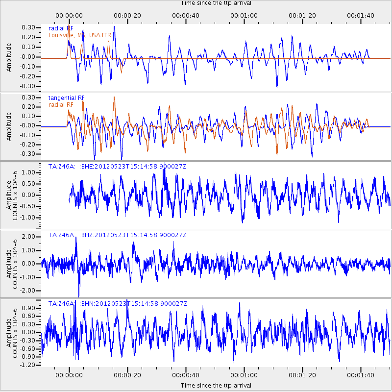
Z46A Louisville, MS, USA - Earthquake Result Viewer
*The percent match for this event was below the threshold and hence no stack was calculated.
| Earthquake location: |
Hokkaido, Japan Region |
| Earthquake latitude/longitude: |
41.3/142.1 |
| Earthquake time(UTC): |
2012/05/23 (144) 15:02:25 GMT |
| Earthquake Depth: |
46 km |
| Earthquake Magnitude: |
6.2 MB, 5.5 MS, 5.9 MW, 6.0 MW |
| Earthquake Catalog/Contributor: |
WHDF/NEIC |
|
| Network: |
TA USArray Transportable Network (new EarthScope stations) |
| Station: |
Z46A Louisville, MS, USA |
| Lat/Lon: |
33.19 N/88.94 W |
| Elevation: |
125 m |
|
| Distance: |
92.2 deg |
| Az: |
40.719 deg |
| Baz: |
324.136 deg |
| Ray Param: |
$rayparam |
*The percent match for this event was below the threshold and hence was not used in the summary stack. |
|
| Radial Match: |
50.478615 % |
| Radial Bump: |
377 |
| Transverse Match: |
61.543938 % |
| Transverse Bump: |
345 |
| SOD ConfigId: |
446234 |
| Insert Time: |
2012-08-25 20:31:32.711 +0000 |
| GWidth: |
2.5 |
| Max Bumps: |
400 |
| Tol: |
0.001 |
|
Signal To Noise
| Channel | StoN | STA | LTA |
| TA:Z46A: :BHZ:20120523T15:14:58.900027Z | 2.536053 | 6.818496E-7 | 2.6886252E-7 |
| TA:Z46A: :BHN:20120523T15:14:58.900027Z | 1.1209235 | 4.058442E-7 | 3.6206234E-7 |
| TA:Z46A: :BHE:20120523T15:14:58.900027Z | 1.6596042 | 5.9155377E-7 | 3.5644268E-7 |
| Arrivals |
| Ps | |
| PpPs | |
| PsPs/PpSs | |


