You are here: Home > Network List > TA - USArray Transportable Network (new EarthScope stations) Stations List
> Station W45A Hickory Valley, TN, USA > Earthquake Result Viewer
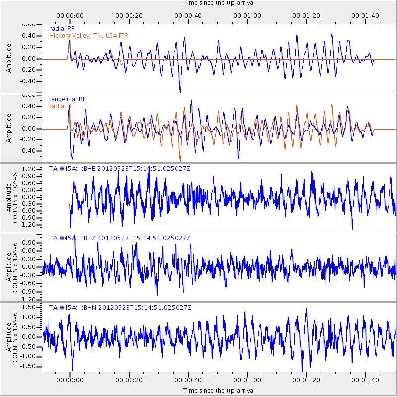
W45A Hickory Valley, TN, USA - Earthquake Result Viewer
*The percent match for this event was below the threshold and hence no stack was calculated.
| Earthquake location: |
Hokkaido, Japan Region |
| Earthquake latitude/longitude: |
41.3/142.1 |
| Earthquake time(UTC): |
2012/05/23 (144) 15:02:25 GMT |
| Earthquake Depth: |
46 km |
| Earthquake Magnitude: |
6.2 MB, 5.5 MS, 5.9 MW, 6.0 MW |
| Earthquake Catalog/Contributor: |
WHDF/NEIC |
|
| Network: |
TA USArray Transportable Network (new EarthScope stations) |
| Station: |
W45A Hickory Valley, TN, USA |
| Lat/Lon: |
35.16 N/89.19 W |
| Elevation: |
187 m |
|
| Distance: |
90.5 deg |
| Az: |
39.734 deg |
| Baz: |
324.022 deg |
| Ray Param: |
$rayparam |
*The percent match for this event was below the threshold and hence was not used in the summary stack. |
|
| Radial Match: |
46.45256 % |
| Radial Bump: |
400 |
| Transverse Match: |
37.382053 % |
| Transverse Bump: |
371 |
| SOD ConfigId: |
446234 |
| Insert Time: |
2012-08-25 20:32:25.360 +0000 |
| GWidth: |
2.5 |
| Max Bumps: |
400 |
| Tol: |
0.001 |
|
Signal To Noise
| Channel | StoN | STA | LTA |
| TA:W45A: :BHZ:20120523T15:14:51.025027Z | 2.3728518 | 4.2365886E-7 | 1.7854417E-7 |
| TA:W45A: :BHN:20120523T15:14:51.025027Z | 0.9190957 | 6.184723E-7 | 6.72914E-7 |
| TA:W45A: :BHE:20120523T15:14:51.025027Z | 0.9273169 | 4.3814322E-7 | 4.7248488E-7 |
| Arrivals |
| Ps | |
| PpPs | |
| PsPs/PpSs | |


