You are here: Home > Network List > TA - USArray Transportable Network (new EarthScope stations) Stations List
> Station S42A Caledonia, MO, USA > Earthquake Result Viewer
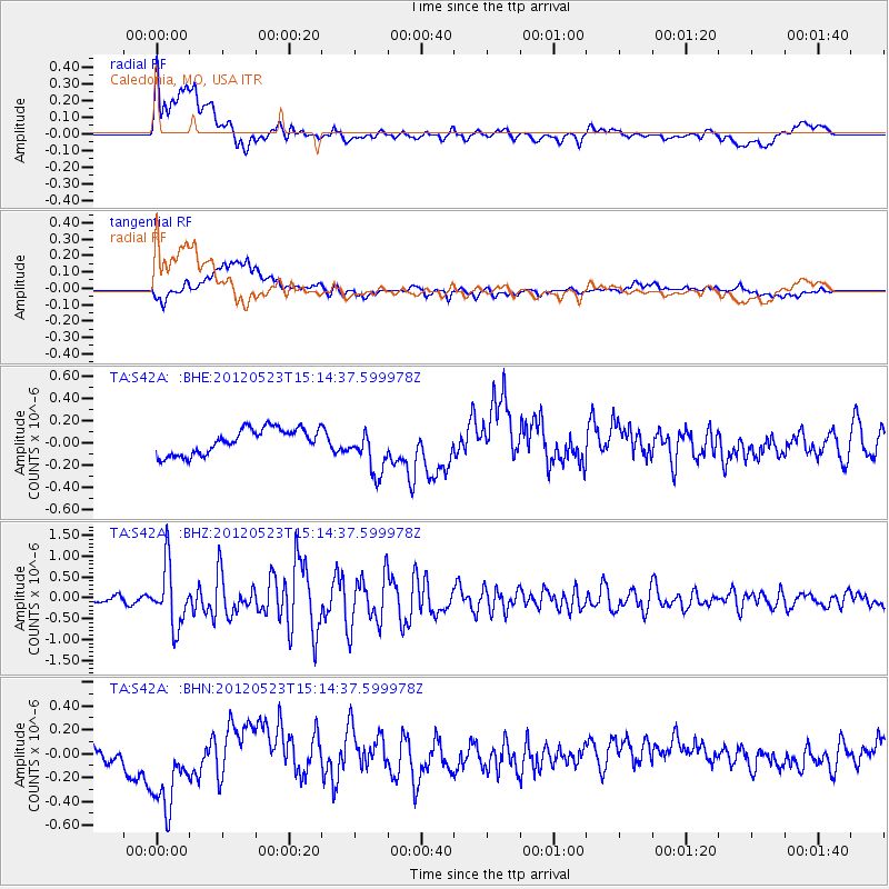
S42A Caledonia, MO, USA - Earthquake Result Viewer
*The percent match for this event was below the threshold and hence no stack was calculated.
| Earthquake location: |
Hokkaido, Japan Region |
| Earthquake latitude/longitude: |
41.3/142.1 |
| Earthquake time(UTC): |
2012/05/23 (144) 15:02:25 GMT |
| Earthquake Depth: |
46 km |
| Earthquake Magnitude: |
6.2 MB, 5.5 MS, 5.9 MW, 6.0 MW |
| Earthquake Catalog/Contributor: |
WHDF/NEIC |
|
| Network: |
TA USArray Transportable Network (new EarthScope stations) |
| Station: |
S42A Caledonia, MO, USA |
| Lat/Lon: |
37.77 N/90.79 W |
| Elevation: |
315 m |
|
| Distance: |
87.6 deg |
| Az: |
39.227 deg |
| Baz: |
323.063 deg |
| Ray Param: |
$rayparam |
*The percent match for this event was below the threshold and hence was not used in the summary stack. |
|
| Radial Match: |
70.80387 % |
| Radial Bump: |
400 |
| Transverse Match: |
32.31814 % |
| Transverse Bump: |
400 |
| SOD ConfigId: |
446234 |
| Insert Time: |
2012-08-25 20:34:15.798 +0000 |
| GWidth: |
2.5 |
| Max Bumps: |
400 |
| Tol: |
0.001 |
|
Signal To Noise
| Channel | StoN | STA | LTA |
| TA:S42A: :BHZ:20120523T15:14:37.599978Z | 11.052607 | 7.1873967E-7 | 6.502898E-8 |
| TA:S42A: :BHN:20120523T15:14:37.599978Z | 4.8881364 | 4.228321E-7 | 8.65017E-8 |
| TA:S42A: :BHE:20120523T15:14:37.599978Z | 1.8170975 | 2.0859136E-7 | 1.1479371E-7 |
| Arrivals |
| Ps | |
| PpPs | |
| PsPs/PpSs | |


