You are here: Home > Network List > G - GEOSCOPE Stations List
> Station RER Riviere de l'Est, La Reunion (Indian Ocean) > Earthquake Result Viewer
RER Riviere de l'Est, La Reunion (Indian Ocean) - Earthquake Result Viewer
| Earthquake location: |
South Sandwich Islands Region |
| Earthquake latitude/longitude: |
-55.8/-27.0 |
| Earthquake time(UTC): |
2007/01/21 (021) 15:03:16 GMT |
| Earthquake Depth: |
48 km |
| Earthquake Magnitude: |
5.6 MB |
| Earthquake Catalog/Contributor: |
WHDF/NEIC |
|
| Network: |
G GEOSCOPE |
| Station: |
RER Riviere de l'Est, La Reunion (Indian Ocean) |
| Lat/Lon: |
21.16 S/55.75 E |
| Elevation: |
834 m |
|
| Distance: |
68.7 deg |
| Az: |
96.519 deg |
| Baz: |
216.985 deg |
| Ray Param: |
0.05600907 |
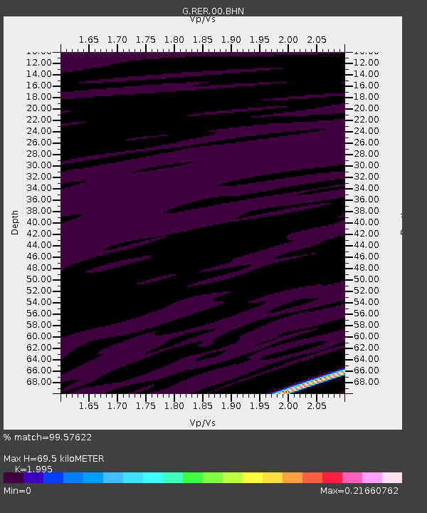
| Estimated Moho Depth: |
69.5 km |
| Estimated Crust Vp/Vs: |
2.00 |
| Assumed Crust Vp: |
4.73 km/s |
| Estimated Crust Vs: |
2.371 km/s |
| Estimated Crust Poisson's Ratio: |
0.33 |
|
| Radial Match: |
99.57622 % |
| Radial Bump: |
37 |
| Transverse Match: |
99.504486 % |
| Transverse Bump: |
32 |
| SOD ConfigId: |
2564 |
| Insert Time: |
2010-02-26 23:43:44.327 +0000 |
| GWidth: |
2.5 |
| Max Bumps: |
400 |
| Tol: |
0.001 |
|
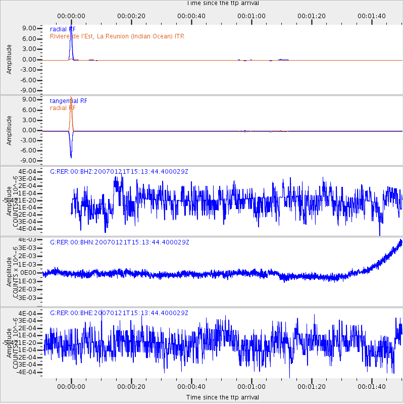
Signal To Noise
| Channel | StoN | STA | LTA |
| G:RER:00:BHN:20070121T15:13:44.400029Z | 0.8847333 | 3.7582532E-10 | 4.247894E-10 |
| G:RER:00:BHE:20070121T15:13:44.400029Z | 0.8652093 | 1.386481E-10 | 1.6024806E-10 |
| G:RER:00:BHZ:20070121T15:13:44.400029Z | 0.7823898 | 1.2497259E-10 | 1.5973187E-10 |
| Arrivals |
| Ps | 15 SECOND |
| PpPs | 43 SECOND |
| PsPs/PpSs | 58 SECOND |


