You are here: Home > Network List > TA - USArray Transportable Network (new EarthScope stations) Stations List
> Station D41A Chassel, MI, USA > Earthquake Result Viewer
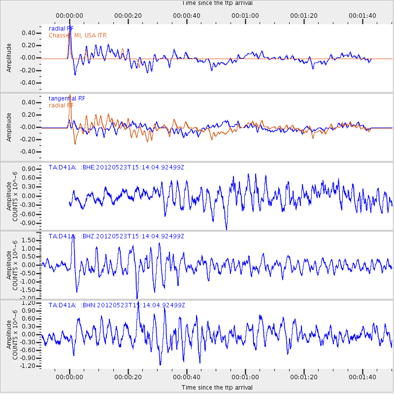
D41A Chassel, MI, USA - Earthquake Result Viewer
*The percent match for this event was below the threshold and hence no stack was calculated.
| Earthquake location: |
Hokkaido, Japan Region |
| Earthquake latitude/longitude: |
41.3/142.1 |
| Earthquake time(UTC): |
2012/05/23 (144) 15:02:25 GMT |
| Earthquake Depth: |
46 km |
| Earthquake Magnitude: |
6.2 MB, 5.5 MS, 5.9 MW, 6.0 MW |
| Earthquake Catalog/Contributor: |
WHDF/NEIC |
|
| Network: |
TA USArray Transportable Network (new EarthScope stations) |
| Station: |
D41A Chassel, MI, USA |
| Lat/Lon: |
47.06 N/88.57 W |
| Elevation: |
271 m |
|
| Distance: |
81.2 deg |
| Az: |
32.345 deg |
| Baz: |
323.892 deg |
| Ray Param: |
$rayparam |
*The percent match for this event was below the threshold and hence was not used in the summary stack. |
|
| Radial Match: |
77.29062 % |
| Radial Bump: |
400 |
| Transverse Match: |
64.69522 % |
| Transverse Bump: |
400 |
| SOD ConfigId: |
446234 |
| Insert Time: |
2012-08-25 20:37:29.937 +0000 |
| GWidth: |
2.5 |
| Max Bumps: |
400 |
| Tol: |
0.001 |
|
Signal To Noise
| Channel | StoN | STA | LTA |
| TA:D41A: :BHZ:20120523T15:14:04.92499Z | 5.9379296 | 8.976278E-7 | 1.5116848E-7 |
| TA:D41A: :BHN:20120523T15:14:04.92499Z | 2.4234946 | 3.69129E-7 | 1.523127E-7 |
| TA:D41A: :BHE:20120523T15:14:04.92499Z | 1.9109294 | 3.1392716E-7 | 1.6427984E-7 |
| Arrivals |
| Ps | |
| PpPs | |
| PsPs/PpSs | |


