You are here: Home > Network List > TA - USArray Transportable Network (new EarthScope stations) Stations List
> Station N46A Monticello, IN, USA > Earthquake Result Viewer
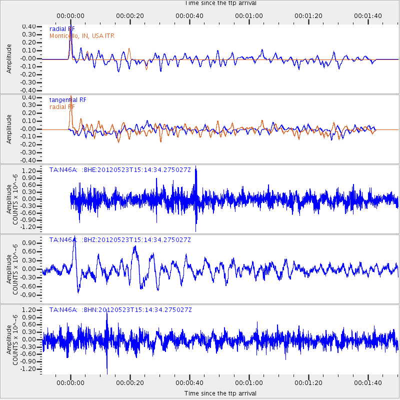
N46A Monticello, IN, USA - Earthquake Result Viewer
*The percent match for this event was below the threshold and hence no stack was calculated.
| Earthquake location: |
Hokkaido, Japan Region |
| Earthquake latitude/longitude: |
41.3/142.1 |
| Earthquake time(UTC): |
2012/05/23 (144) 15:02:25 GMT |
| Earthquake Depth: |
46 km |
| Earthquake Magnitude: |
6.2 MB, 5.5 MS, 5.9 MW, 6.0 MW |
| Earthquake Catalog/Contributor: |
WHDF/NEIC |
|
| Network: |
TA USArray Transportable Network (new EarthScope stations) |
| Station: |
N46A Monticello, IN, USA |
| Lat/Lon: |
40.89 N/86.74 W |
| Elevation: |
209 m |
|
| Distance: |
87.0 deg |
| Az: |
34.845 deg |
| Baz: |
325.42 deg |
| Ray Param: |
$rayparam |
*The percent match for this event was below the threshold and hence was not used in the summary stack. |
|
| Radial Match: |
79.1884 % |
| Radial Bump: |
400 |
| Transverse Match: |
61.871002 % |
| Transverse Bump: |
400 |
| SOD ConfigId: |
446234 |
| Insert Time: |
2012-08-25 20:39:02.714 +0000 |
| GWidth: |
2.5 |
| Max Bumps: |
400 |
| Tol: |
0.001 |
|
Signal To Noise
| Channel | StoN | STA | LTA |
| TA:N46A: :BHZ:20120523T15:14:34.275027Z | 4.349691 | 4.9392577E-7 | 1.1355423E-7 |
| TA:N46A: :BHN:20120523T15:14:34.275027Z | 1.3433101 | 2.6541167E-7 | 1.9758033E-7 |
| TA:N46A: :BHE:20120523T15:14:34.275027Z | 1.3081062 | 2.983808E-7 | 2.2810137E-7 |
| Arrivals |
| Ps | |
| PpPs | |
| PsPs/PpSs | |


