You are here: Home > Network List > G - GEOSCOPE Stations List
> Station RER Riviere de l'Est, La Reunion (Indian Ocean) > Earthquake Result Viewer
RER Riviere de l'Est, La Reunion (Indian Ocean) - Earthquake Result Viewer

| Earthquake location: |
Drake Passage |
| Earthquake latitude/longitude: |
-57.9/-64.5 |
| Earthquake time(UTC): |
2007/01/17 (017) 18:34:14 GMT |
| Earthquake Depth: |
6.0 km |
| Earthquake Magnitude: |
5.6 MB, 5.1 MS, 5.6 MW, 5.6 MW |
| Earthquake Catalog/Contributor: |
WHDF/NEIC |
|
| Network: |
G GEOSCOPE |
| Station: |
RER Riviere de l'Est, La Reunion (Indian Ocean) |
| Lat/Lon: |
21.16 S/55.75 E |
| Elevation: |
834 m |
|
| Distance: |
87.0 deg |
| Az: |
126.176 deg |
| Baz: |
207.492 deg |
| Ray Param: |
0.043645333 |
| Estimated Moho Depth: |
68.25 km |
| Estimated Crust Vp/Vs: |
1.96 |
| Assumed Crust Vp: |
4.73 km/s |
| Estimated Crust Vs: |
2.419 km/s |
| Estimated Crust Poisson's Ratio: |
0.32 |
|
| Radial Match: |
98.98901 % |
| Radial Bump: |
50 |
| Transverse Match: |
98.946846 % |
| Transverse Bump: |
52 |
| SOD ConfigId: |
2564 |
| Insert Time: |
2010-02-26 23:43:49.963 +0000 |
| GWidth: |
2.5 |
| Max Bumps: |
400 |
| Tol: |
0.001 |
|
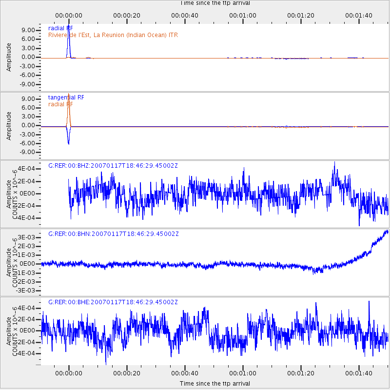
Signal To Noise
| Channel | StoN | STA | LTA |
| G:RER:00:BHN:20070117T18:46:29.45002Z | 1.1343217 | 3.6720862E-10 | 3.2372532E-10 |
| G:RER:00:BHE:20070117T18:46:29.45002Z | 0.9332004 | 1.3069436E-10 | 1.4004961E-10 |
| G:RER:00:BHZ:20070117T18:46:29.45002Z | 0.6624643 | 9.9584944E-11 | 1.5032499E-10 |
| Arrivals |
| Ps | 14 SECOND |
| PpPs | 42 SECOND |
| PsPs/PpSs | 56 SECOND |


