You are here: Home > Network List > G - GEOSCOPE Stations List
> Station RER Riviere de l'Est, La Reunion (Indian Ocean) > Earthquake Result Viewer
RER Riviere de l'Est, La Reunion (Indian Ocean) - Earthquake Result Viewer
| Earthquake location: |
Sichuan, China |
| Earthquake latitude/longitude: |
31.0/103.3 |
| Earthquake time(UTC): |
2008/05/12 (133) 06:28:01 GMT |
| Earthquake Depth: |
19 km |
| Earthquake Magnitude: |
6.9 MB, 8.1 MS, 7.9 MW, 7.9 MW |
| Earthquake Catalog/Contributor: |
WHDF/NEIC |
|
| Network: |
G GEOSCOPE |
| Station: |
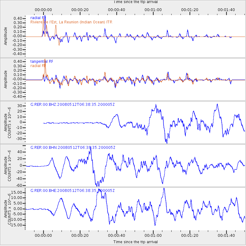
RER Riviere de l'Est, La Reunion (Indian Ocean) |
| Lat/Lon: |
21.16 S/55.75 E |
| Elevation: |
834 m |
|
| Distance: |
69.1 deg |
| Az: |
227.522 deg |
| Baz: |
42.726 deg |
| Ray Param: |
0.055853557 |
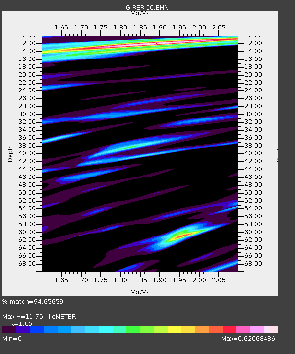
| Estimated Moho Depth: |
11.75 km |
| Estimated Crust Vp/Vs: |
1.89 |
| Assumed Crust Vp: |
4.73 km/s |
| Estimated Crust Vs: |
2.503 km/s |
| Estimated Crust Poisson's Ratio: |
0.31 |
|
| Radial Match: |
94.65659 % |
| Radial Bump: |
400 |
| Transverse Match: |
82.95065 % |
| Transverse Bump: |
400 |
| SOD ConfigId: |
2504 |
| Insert Time: |
2010-02-26 23:43:55.438 +0000 |
| GWidth: |
2.5 |
| Max Bumps: |
400 |
| Tol: |
0.001 |
|
Signal To Noise
| Channel | StoN | STA | LTA |
| G:RER:00:BHN:20080512T06:38:35.200005Z | 12.242893 | 9.776194E-6 | 7.9851986E-7 |
| G:RER:00:BHE:20080512T06:38:35.200005Z | 5.18067 | 1.4864318E-6 | 2.8691886E-7 |
| G:RER:00:BHZ:20080512T06:38:35.200005Z | 5.3470216 | 2.4444107E-6 | 4.5715373E-7 |
| Arrivals |
| Ps | 2.3 SECOND |
| PpPs | 7.0 SECOND |
| PsPs/PpSs | 9.3 SECOND |


