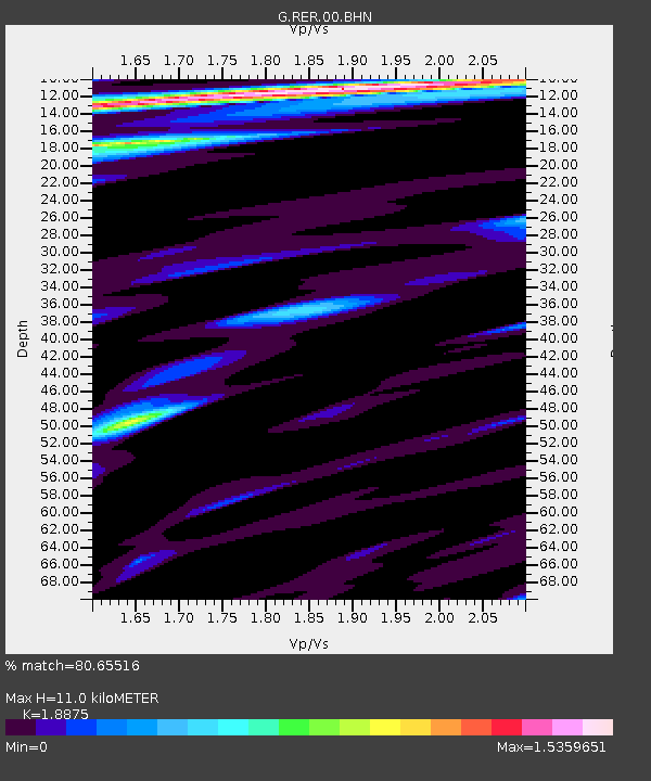
RER Riviere de l'Est, La Reunion (Indian Ocean) - Earthquake Result Viewer
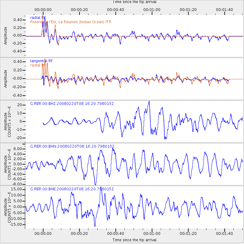
Earthquake location: Off W Coast Of Northern Sumatra
Earthquake latitude/longitude: 2.8/96.0
Earthquake time(UTC): 2008/02/20 (051) 08:08:30 GMT
Earthquake Depth: 26 km
Earthquake Magnitude: 6.5 MB, 7.5 MS, 7.4 MW, 7.4 MW
Earthquake Catalog/Contributor: WHDF/NEIC
Network: G GEOSCOPE
Station: RER Riviere de l'Est, La Reunion (Indian Ocean)
Lat/Lon: 21.16 S/55.75 E
Elevation: 834 m
Distance: 46.0 deg
Az: 236.917 deg
Baz: 63.72 deg
Ray Param: 0.0708749
Estimated Moho Depth: 11.0 km
Estimated Crust Vp/Vs: 1.89
Assumed Crust Vp: 4.73 km/s
Estimated Crust Vs: 2.506 km/s
Estimated Crust Poisson's Ratio: 0.30
Radial Match: 80.65516 %
Radial Bump: 400
Transverse Match: 59.105446 %
Transverse Bump: 400
SOD ConfigId: 2564
Insert Time: 2010-02-26 23:43:57.075 +0000
GWidth: 2.5
Max Bumps: 400
Tol: 0.001

Signal To Noise

ChannelStoNSTALTA
G:RER:00:BHN:20080220T08:16:20.798015Z0.402381666.517727E-71.6197873E-6
G:RER:00:BHE:20080220T08:16:20.798015Z0.738584643.587505E-64.85727E-6
G:RER:00:BHZ:20080220T08:16:20.798015Z3.02688076.949103E-62.2957968E-6
Arrivals
Ps2.1 SECOND
PpPs6.5 SECOND
PsPs/PpSs8.6 SECOND