You are here: Home > Network List > G - GEOSCOPE Stations List
> Station RER Riviere de l'Est, La Reunion (Indian Ocean) > Earthquake Result Viewer
RER Riviere de l'Est, La Reunion (Indian Ocean) - Earthquake Result Viewer

| Earthquake location: |
Taiwan Region |
| Earthquake latitude/longitude: |
22.5/118.7 |
| Earthquake time(UTC): |
1994/09/16 (259) 06:20:18 GMT |
| Earthquake Depth: |
12 km |
| Earthquake Magnitude: |
6.5 MB, 6.7 MS, 6.8 UNKNOWN, 6.7 MW |
| Earthquake Catalog/Contributor: |
WHDF/NEIC |
|
| Network: |
G GEOSCOPE |
| Station: |
RER Riviere de l'Est, La Reunion (Indian Ocean) |
| Lat/Lon: |
21.16 S/55.75 E |
| Elevation: |
834 m |
|
| Distance: |
75.2 deg |
| Az: |
239.324 deg |
| Baz: |
58.414 deg |
| Ray Param: |
0.051806264 |
| Estimated Moho Depth: |
66.0 km |
| Estimated Crust Vp/Vs: |
2.10 |
| Assumed Crust Vp: |
4.73 km/s |
| Estimated Crust Vs: |
2.255 km/s |
| Estimated Crust Poisson's Ratio: |
0.35 |
|
| Radial Match: |
84.658 % |
| Radial Bump: |
400 |
| Transverse Match: |
70.6028 % |
| Transverse Bump: |
400 |
| SOD ConfigId: |
17000 |
| Insert Time: |
2010-02-26 23:44:00.855 +0000 |
| GWidth: |
2.5 |
| Max Bumps: |
400 |
| Tol: |
0.001 |
|
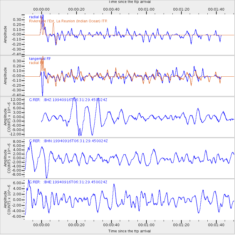
Signal To Noise
| Channel | StoN | STA | LTA |
| G:RER: :BHN:19940916T06:31:29.450024Z | 1.8588537 | 5.139934E-6 | 2.7651092E-6 |
| G:RER: :BHE:19940916T06:31:29.450024Z | 0.8925641 | 2.54704E-6 | 2.8536213E-6 |
| G:RER: :BHZ:19940916T06:31:29.450024Z | 1.5279915 | 8.368361E-6 | 5.4767065E-6 |
| Arrivals |
| Ps | 16 SECOND |
| PpPs | 43 SECOND |
| PsPs/PpSs | 58 SECOND |


