You are here: Home > Network List > G - GEOSCOPE Stations List
> Station RER Riviere de l'Est, La Reunion (Indian Ocean) > Earthquake Result Viewer
RER Riviere de l'Est, La Reunion (Indian Ocean) - Earthquake Result Viewer
| Earthquake location: |
Taiwan Region |
| Earthquake latitude/longitude: |
21.9/121.5 |
| Earthquake time(UTC): |
1996/09/05 (249) 23:42:06 GMT |
| Earthquake Depth: |
20 km |
| Earthquake Magnitude: |
6.4 MB, 6.6 MS, 6.8 UNKNOWN, 6.8 ME |
| Earthquake Catalog/Contributor: |
WHDF/NEIC |
|
| Network: |
G GEOSCOPE |
| Station: |
RER Riviere de l'Est, La Reunion (Indian Ocean) |
| Lat/Lon: |
21.16 S/55.75 E |
| Elevation: |
834 m |
|
| Distance: |
77.1 deg |
| Az: |
240.811 deg |
| Baz: |
60.301 deg |
| Ray Param: |
0.050519954 |
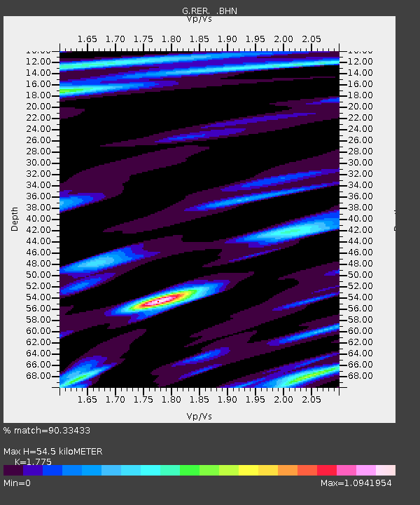
| Estimated Moho Depth: |
54.5 km |
| Estimated Crust Vp/Vs: |
1.77 |
| Assumed Crust Vp: |
4.73 km/s |
| Estimated Crust Vs: |
2.665 km/s |
| Estimated Crust Poisson's Ratio: |
0.27 |
|
| Radial Match: |
90.33433 % |
| Radial Bump: |
400 |
| Transverse Match: |
76.85057 % |
| Transverse Bump: |
400 |
| SOD ConfigId: |
6273 |
| Insert Time: |
2010-02-26 23:44:08.926 +0000 |
| GWidth: |
2.5 |
| Max Bumps: |
400 |
| Tol: |
0.001 |
|
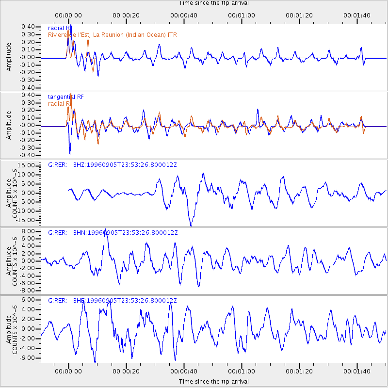
Signal To Noise
| Channel | StoN | STA | LTA |
| G:RER: :BHN:19960905T23:53:26.800012Z | 1.5429425 | 1.0086559E-6 | 6.537223E-7 |
| G:RER: :BHE:19960905T23:53:26.800012Z | 2.751569 | 2.7575693E-6 | 1.0021806E-6 |
| G:RER: :BHZ:19960905T23:53:26.800012Z | 3.396195 | 5.2818696E-6 | 1.5552315E-6 |
| Arrivals |
| Ps | 9.1 SECOND |
| PpPs | 31 SECOND |
| PsPs/PpSs | 41 SECOND |


