You are here: Home > Network List > G - GEOSCOPE Stations List
> Station RER Riviere de l'Est, La Reunion (Indian Ocean) > Earthquake Result Viewer
RER Riviere de l'Est, La Reunion (Indian Ocean) - Earthquake Result Viewer
| Earthquake location: |
Eastern Kashmir |
| Earthquake latitude/longitude: |
35.3/78.1 |
| Earthquake time(UTC): |
1996/11/19 (324) 10:44:46 GMT |
| Earthquake Depth: |
33 km |
| Earthquake Magnitude: |
6.1 MB, 7.1 MS, 6.9 UNKNOWN, 6.8 MW |
| Earthquake Catalog/Contributor: |
WHDF/NEIC |
|
| Network: |
G GEOSCOPE |
| Station: |
RER Riviere de l'Est, La Reunion (Indian Ocean) |
| Lat/Lon: |
21.16 S/55.75 E |
| Elevation: |
834 m |
|
| Distance: |
60.1 deg |
| Az: |
204.216 deg |
| Baz: |
21.055 deg |
| Ray Param: |
0.061715614 |
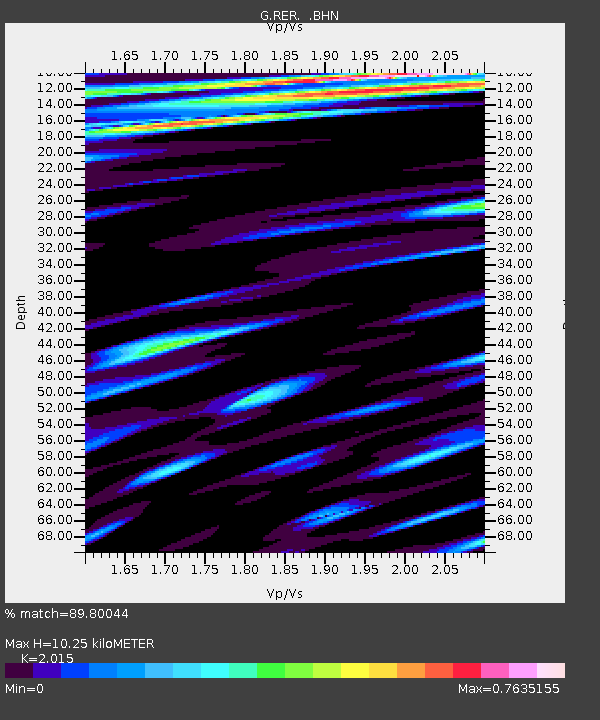
| Estimated Moho Depth: |
10.25 km |
| Estimated Crust Vp/Vs: |
2.02 |
| Assumed Crust Vp: |
4.73 km/s |
| Estimated Crust Vs: |
2.347 km/s |
| Estimated Crust Poisson's Ratio: |
0.34 |
|
| Radial Match: |
89.80044 % |
| Radial Bump: |
320 |
| Transverse Match: |
72.808205 % |
| Transverse Bump: |
400 |
| SOD ConfigId: |
6273 |
| Insert Time: |
2010-02-26 23:44:10.627 +0000 |
| GWidth: |
2.5 |
| Max Bumps: |
400 |
| Tol: |
0.001 |
|
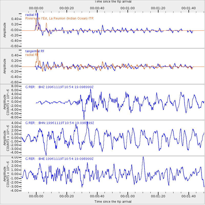
Signal To Noise
| Channel | StoN | STA | LTA |
| G:RER: :BHN:19961119T10:54:19.098999Z | 2.9791493 | 1.4449708E-6 | 4.85028E-7 |
| G:RER: :BHE:19961119T10:54:19.098999Z | 2.4372506 | 1.2199012E-6 | 5.005235E-7 |
| G:RER: :BHZ:19961119T10:54:19.098999Z | 7.668158 | 3.4586424E-6 | 4.510395E-7 |
| Arrivals |
| Ps | 2.2 SECOND |
| PpPs | 6.4 SECOND |
| PsPs/PpSs | 8.6 SECOND |


