RER Riviere de l'Est, La Reunion (Indian Ocean) - Earthquake Result Viewer
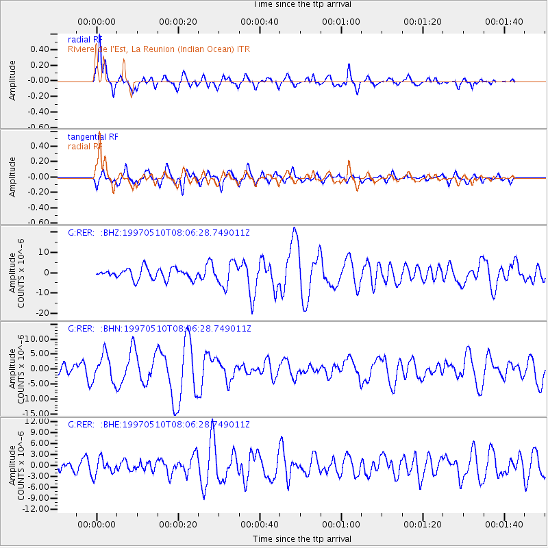
Earthquake location: Northern And Central Iran
Earthquake latitude/longitude: 33.8/59.8
Earthquake time(UTC): 1997/05/10 (130) 07:57:29 GMT
Earthquake Depth: 10 km
Earthquake Magnitude: 6.4 MB, 7.3 MS, 7.5 UNKNOWN, 7.2 MW
Earthquake Catalog/Contributor: WHDF/NEIC
Network: G GEOSCOPE
Station: RER Riviere de l'Est, La Reunion (Indian Ocean)
Lat/Lon: 21.16 S/55.75 E
Elevation: 834 m
Distance: 54.8 deg
Az: 184.641 deg
Baz: 4.139 deg
Ray Param: 0.06520835
Estimated Moho Depth: 13.75 km
Estimated Crust Vp/Vs: 1.75
Assumed Crust Vp: 4.73 km/s
Estimated Crust Vs: 2.699 km/s
Estimated Crust Poisson's Ratio: 0.26
Radial Match: 86.87355 %
Radial Bump: 400
Transverse Match: 68.92029 %
Transverse Bump: 400
SOD ConfigId: 6273
Insert Time: 2010-02-26 23:44:11.758 +0000
GWidth: 2.5
Max Bumps: 400
Tol: 0.001

Signal To Noise

ChannelStoNSTALTA
G:RER: :BHN:19970510T08:06:28.749011Z2.7340174.64098E-61.697495E-6
G:RER: :BHE:19970510T08:06:28.749011Z1.59832582.1910141E-61.3708183E-6
G:RER: :BHZ:19970510T08:06:28.749011Z2.19505555.710149E-62.6013686E-6
Arrivals
Ps2.2 SECOND
PpPs7.8 SECOND
PsPs/PpSs10 SECOND