You are here: Home > Network List > II - Global Seismograph Network (GSN - IRIS/IDA) Stations List
> Station ABKT Alibek, Turkmenistan > Earthquake Result Viewer
ABKT Alibek, Turkmenistan - Earthquake Result Viewer
| Earthquake location: |
Norwegian Sea |
| Earthquake latitude/longitude: |
73.0/5.7 |
| Earthquake time(UTC): |
2012/05/24 (145) 22:47:46 GMT |
| Earthquake Depth: |
10 km |
| Earthquake Magnitude: |
5.7 MB, 6.1 MS, 6.1 MW, 6.2 MW |
| Earthquake Catalog/Contributor: |
WHDF/NEIC |
|
| Network: |
II Global Seismograph Network (GSN - IRIS/IDA) |
| Station: |
ABKT Alibek, Turkmenistan |
| Lat/Lon: |
37.93 N/58.12 E |
| Elevation: |
678 m |
|
| Distance: |
43.4 deg |
| Az: |
114.083 deg |
| Baz: |
340.098 deg |
| Ray Param: |
0.07260299 |
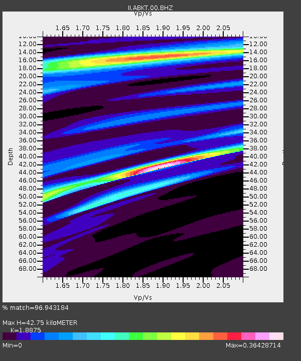
| Estimated Moho Depth: |
42.75 km |
| Estimated Crust Vp/Vs: |
1.89 |
| Assumed Crust Vp: |
6.53 km/s |
| Estimated Crust Vs: |
3.46 km/s |
| Estimated Crust Poisson's Ratio: |
0.30 |
|
| Radial Match: |
96.943184 % |
| Radial Bump: |
150 |
| Transverse Match: |
87.60276 % |
| Transverse Bump: |
332 |
| SOD ConfigId: |
446234 |
| Insert Time: |
2012-08-25 21:07:05.839 +0000 |
| GWidth: |
2.5 |
| Max Bumps: |
400 |
| Tol: |
0.001 |
|
Signal To Noise
| Channel | StoN | STA | LTA |
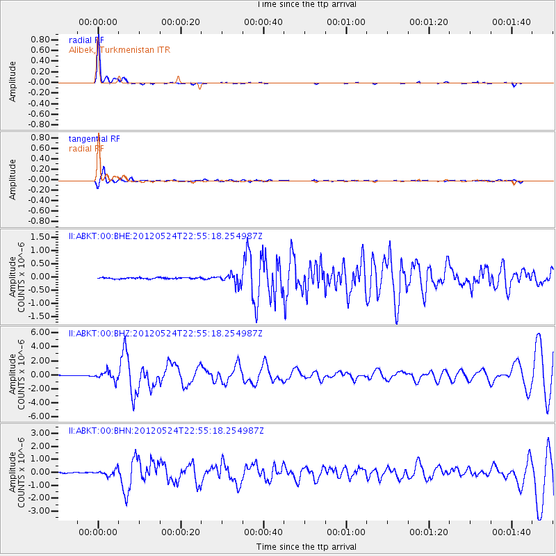
| II:ABKT:00:BHZ:20120524T22:55:18.254987Z | 19.240652 | 6.0551406E-7 | 3.147056E-8 |
| II:ABKT:00:BHN:20120524T22:55:18.254987Z | 6.5118837 | 2.38294E-7 | 3.659371E-8 |
| II:ABKT:00:BHE:20120524T22:55:18.254987Z | 9.387522 | 2.0005258E-7 | 2.1310479E-8 |
| Arrivals |
| Ps | 6.2 SECOND |
| PpPs | 18 SECOND |
| PsPs/PpSs | 24 SECOND |


