You are here: Home > Network List > TA - USArray Transportable Network (new EarthScope stations) Stations List
> Station N60A Cedar Hill Farm, Mount Bethel, PA, USA > Earthquake Result Viewer
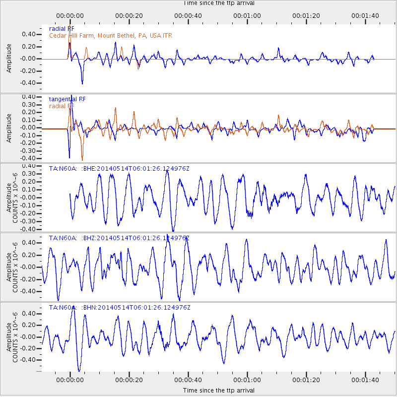
N60A Cedar Hill Farm, Mount Bethel, PA, USA - Earthquake Result Viewer
*The percent match for this event was below the threshold and hence no stack was calculated.
| Earthquake location: |
Near Coast Of Northern Chile |
| Earthquake latitude/longitude: |
-19.7/-71.0 |
| Earthquake time(UTC): |
2014/05/14 (134) 05:51:50 GMT |
| Earthquake Depth: |
27 km |
| Earthquake Magnitude: |
5.3 MW |
| Earthquake Catalog/Contributor: |
ISC/ISC |
|
| Network: |
TA USArray Transportable Network (new EarthScope stations) |
| Station: |
N60A Cedar Hill Farm, Mount Bethel, PA, USA |
| Lat/Lon: |
40.87 N/75.10 W |
| Elevation: |
189 m |
|
| Distance: |
60.4 deg |
| Az: |
356.386 deg |
| Baz: |
175.508 deg |
| Ray Param: |
$rayparam |
*The percent match for this event was below the threshold and hence was not used in the summary stack. |
|
| Radial Match: |
51.38006 % |
| Radial Bump: |
302 |
| Transverse Match: |
48.63028 % |
| Transverse Bump: |
400 |
| SOD ConfigId: |
3390531 |
| Insert Time: |
2019-04-11 21:17:11.488 +0000 |
| GWidth: |
2.5 |
| Max Bumps: |
400 |
| Tol: |
0.001 |
|
Signal To Noise
| Channel | StoN | STA | LTA |
| TA:N60A: :BHZ:20140514T06:01:26.124976Z | 0.6752387 | 1.5182465E-7 | 2.2484589E-7 |
| TA:N60A: :BHN:20140514T06:01:26.124976Z | 2.661599 | 3.5936995E-7 | 1.3502031E-7 |
| TA:N60A: :BHE:20140514T06:01:26.124976Z | 1.1971865 | 2.1666486E-7 | 1.8097838E-7 |
| Arrivals |
| Ps | |
| PpPs | |
| PsPs/PpSs | |


