You are here: Home > Network List > TA - USArray Transportable Network (new EarthScope stations) Stations List
> Station K22A Casper, WY, USA > Earthquake Result Viewer
K22A Casper, WY, USA - Earthquake Result Viewer
| Earthquake location: |
Norwegian Sea |
| Earthquake latitude/longitude: |
73.0/5.7 |
| Earthquake time(UTC): |
2012/05/24 (145) 22:47:46 GMT |
| Earthquake Depth: |
10 km |
| Earthquake Magnitude: |
5.7 MB, 6.1 MS, 6.1 MW, 6.2 MW |
| Earthquake Catalog/Contributor: |
WHDF/NEIC |
|
| Network: |
TA USArray Transportable Network (new EarthScope stations) |
| Station: |
K22A Casper, WY, USA |
| Lat/Lon: |
42.65 N/106.52 W |
| Elevation: |
1686 m |
|
| Distance: |
55.7 deg |
| Az: |
304.274 deg |
| Baz: |
19.284 deg |
| Ray Param: |
0.06459156 |
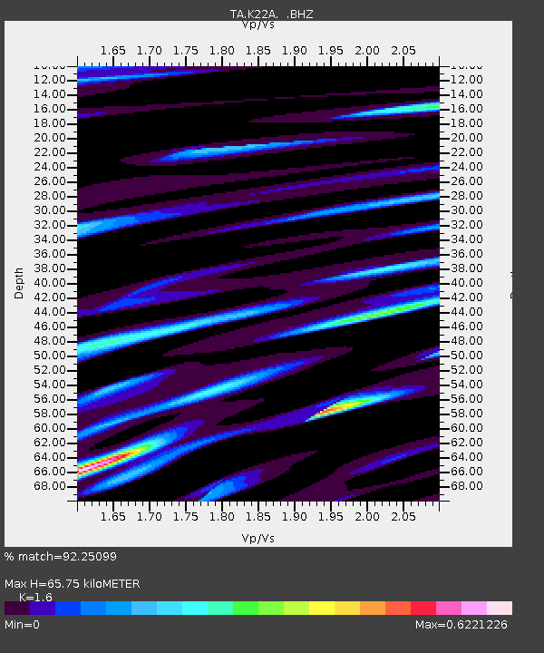
| Estimated Moho Depth: |
65.75 km |
| Estimated Crust Vp/Vs: |
1.60 |
| Assumed Crust Vp: |
6.178 km/s |
| Estimated Crust Vs: |
3.861 km/s |
| Estimated Crust Poisson's Ratio: |
0.18 |
|
| Radial Match: |
92.25099 % |
| Radial Bump: |
400 |
| Transverse Match: |
77.18178 % |
| Transverse Bump: |
400 |
| SOD ConfigId: |
446234 |
| Insert Time: |
2012-08-25 21:14:50.386 +0000 |
| GWidth: |
2.5 |
| Max Bumps: |
400 |
| Tol: |
0.001 |
|

Signal To Noise
| Channel | StoN | STA | LTA |
| TA:K22A: :BHZ:20120524T22:56:52.550Z | 21.836313 | 1.0923391E-6 | 5.0023967E-8 |
| TA:K22A: :BHN:20120524T22:56:52.550Z | 5.344102 | 4.4791904E-7 | 8.381559E-8 |
| TA:K22A: :BHE:20120524T22:56:52.550Z | 2.7660697 | 1.9189122E-7 | 6.937324E-8 |
| Arrivals |
| Ps | 6.7 SECOND |
| PpPs | 26 SECOND |
| PsPs/PpSs | 33 SECOND |


