You are here: Home > Network List > G - GEOSCOPE Stations List
> Station RER Riviere de l'Est, La Reunion (Indian Ocean) > Earthquake Result Viewer
RER Riviere de l'Est, La Reunion (Indian Ocean) - Earthquake Result Viewer
| Earthquake location: |
Qinghai, China |
| Earthquake latitude/longitude: |
35.9/90.5 |
| Earthquake time(UTC): |
2001/11/14 (318) 09:26:10 GMT |
| Earthquake Depth: |
10 km |
| Earthquake Magnitude: |
6.1 MB, 8.0 MS, 7.8 MW, 7.7 MW |
| Earthquake Catalog/Contributor: |
WHDF/NEIC |
|
| Network: |
G GEOSCOPE |
| Station: |
RER Riviere de l'Est, La Reunion (Indian Ocean) |
| Lat/Lon: |
21.16 S/55.75 E |
| Elevation: |
834 m |
|
| Distance: |
65.7 deg |
| Az: |
215.776 deg |
| Baz: |
30.546 deg |
| Ray Param: |
0.05812985 |
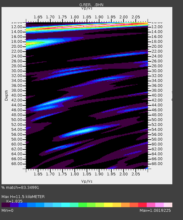
| Estimated Moho Depth: |
11.5 km |
| Estimated Crust Vp/Vs: |
1.84 |
| Assumed Crust Vp: |
4.73 km/s |
| Estimated Crust Vs: |
2.578 km/s |
| Estimated Crust Poisson's Ratio: |
0.29 |
|
| Radial Match: |
83.34991 % |
| Radial Bump: |
349 |
| Transverse Match: |
55.836483 % |
| Transverse Bump: |
400 |
| SOD ConfigId: |
20082 |
| Insert Time: |
2010-02-26 23:44:20.569 +0000 |
| GWidth: |
2.5 |
| Max Bumps: |
400 |
| Tol: |
0.001 |
|
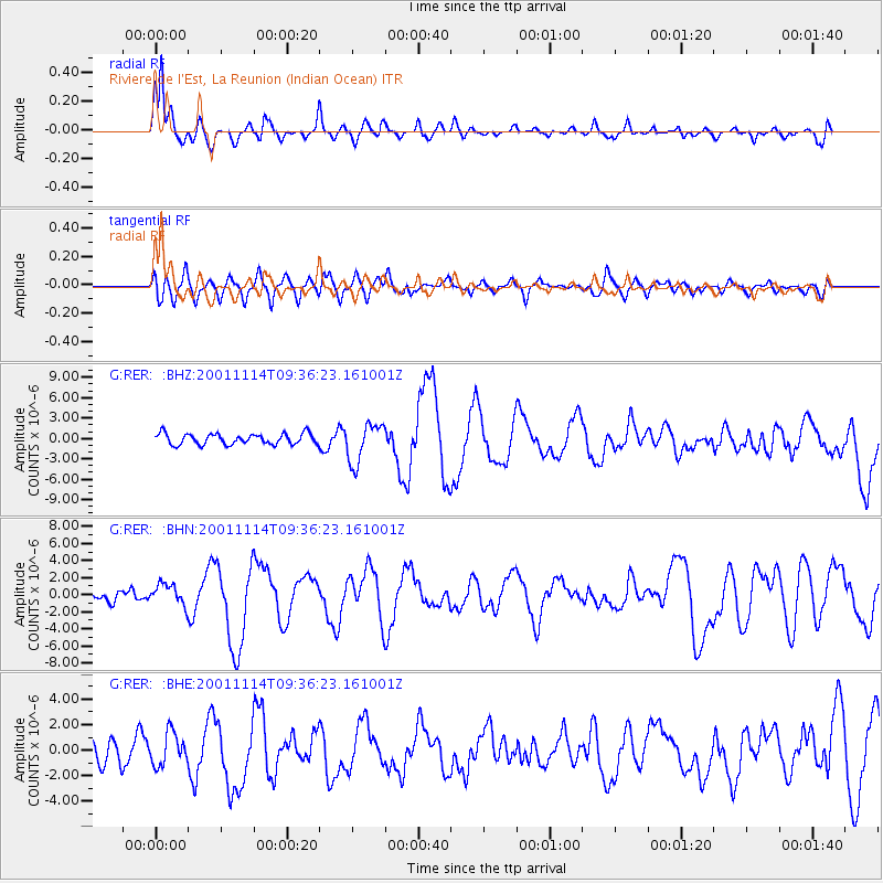
Signal To Noise
| Channel | StoN | STA | LTA |
| G:RER: :BHN:20011114T09:36:23.161001Z | 1.3914934 | 1.2768099E-6 | 9.175825E-7 |
| G:RER: :BHE:20011114T09:36:23.161001Z | 1.5227793 | 1.282109E-6 | 8.419532E-7 |
| G:RER: :BHZ:20011114T09:36:23.161001Z | 3.6317387 | 2.9040275E-6 | 7.996246E-7 |
| Arrivals |
| Ps | 2.1 SECOND |
| PpPs | 6.7 SECOND |
| PsPs/PpSs | 8.8 SECOND |


