You are here: Home > Network List > TA - USArray Transportable Network (new EarthScope stations) Stations List
> Station I31A Royce, Wessington Springs, SD, USA > Earthquake Result Viewer
I31A Royce, Wessington Springs, SD, USA - Earthquake Result Viewer
| Earthquake location: |
Norwegian Sea |
| Earthquake latitude/longitude: |
73.0/5.7 |
| Earthquake time(UTC): |
2012/05/24 (145) 22:47:46 GMT |
| Earthquake Depth: |
10 km |
| Earthquake Magnitude: |
5.7 MB, 6.1 MS, 6.1 MW, 6.2 MW |
| Earthquake Catalog/Contributor: |
WHDF/NEIC |
|
| Network: |
TA USArray Transportable Network (new EarthScope stations) |
| Station: |
I31A Royce, Wessington Springs, SD, USA |
| Lat/Lon: |
44.03 N/98.54 W |
| Elevation: |
469 m |
|
| Distance: |
52.4 deg |
| Az: |
298.11 deg |
| Baz: |
21.134 deg |
| Ray Param: |
0.066758044 |
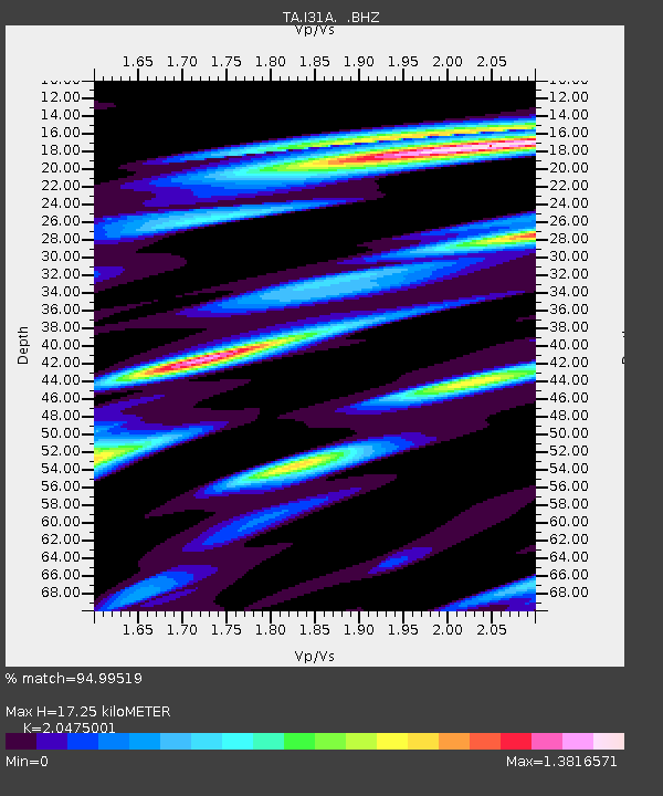
| Estimated Moho Depth: |
17.25 km |
| Estimated Crust Vp/Vs: |
2.05 |
| Assumed Crust Vp: |
6.53 km/s |
| Estimated Crust Vs: |
3.189 km/s |
| Estimated Crust Poisson's Ratio: |
0.34 |
|
| Radial Match: |
94.99519 % |
| Radial Bump: |
400 |
| Transverse Match: |
79.39266 % |
| Transverse Bump: |
400 |
| SOD ConfigId: |
446234 |
| Insert Time: |
2012-08-25 21:16:05.513 +0000 |
| GWidth: |
2.5 |
| Max Bumps: |
400 |
| Tol: |
0.001 |
|
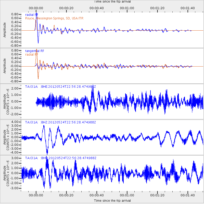
Signal To Noise
| Channel | StoN | STA | LTA |
| TA:I31A: :BHZ:20120524T22:56:28.474988Z | 2.5340948 | 8.783314E-7 | 3.4660556E-7 |
| TA:I31A: :BHN:20120524T22:56:28.474988Z | 0.7798684 | 6.362802E-7 | 8.1588155E-7 |
| TA:I31A: :BHE:20120524T22:56:28.474988Z | 1.0616432 | 5.3509774E-7 | 5.0402787E-7 |
| Arrivals |
| Ps | 2.9 SECOND |
| PpPs | 7.7 SECOND |
| PsPs/PpSs | 11 SECOND |


