You are here: Home > Network List > G - GEOSCOPE Stations List
> Station RER Riviere de l'Est, La Reunion (Indian Ocean) > Earthquake Result Viewer
RER Riviere de l'Est, La Reunion (Indian Ocean) - Earthquake Result Viewer
| Earthquake location: |
Pakistan |
| Earthquake latitude/longitude: |
30.0/68.2 |
| Earthquake time(UTC): |
1997/02/27 (058) 21:08:02 GMT |
| Earthquake Depth: |
33 km |
| Earthquake Magnitude: |
6.3 MB, 7.3 MS, 7.1 UNKNOWN, 6.6 ME |
| Earthquake Catalog/Contributor: |
WHDF/NEIC |
|
| Network: |
G GEOSCOPE |
| Station: |
RER Riviere de l'Est, La Reunion (Indian Ocean) |
| Lat/Lon: |
21.16 S/55.75 E |
| Elevation: |
834 m |
|
| Distance: |
52.2 deg |
| Az: |
194.761 deg |
| Baz: |
13.701 deg |
| Ray Param: |
0.06682811 |
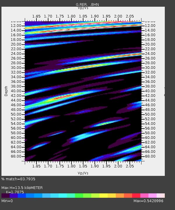
| Estimated Moho Depth: |
13.5 km |
| Estimated Crust Vp/Vs: |
1.79 |
| Assumed Crust Vp: |
4.73 km/s |
| Estimated Crust Vs: |
2.646 km/s |
| Estimated Crust Poisson's Ratio: |
0.27 |
|
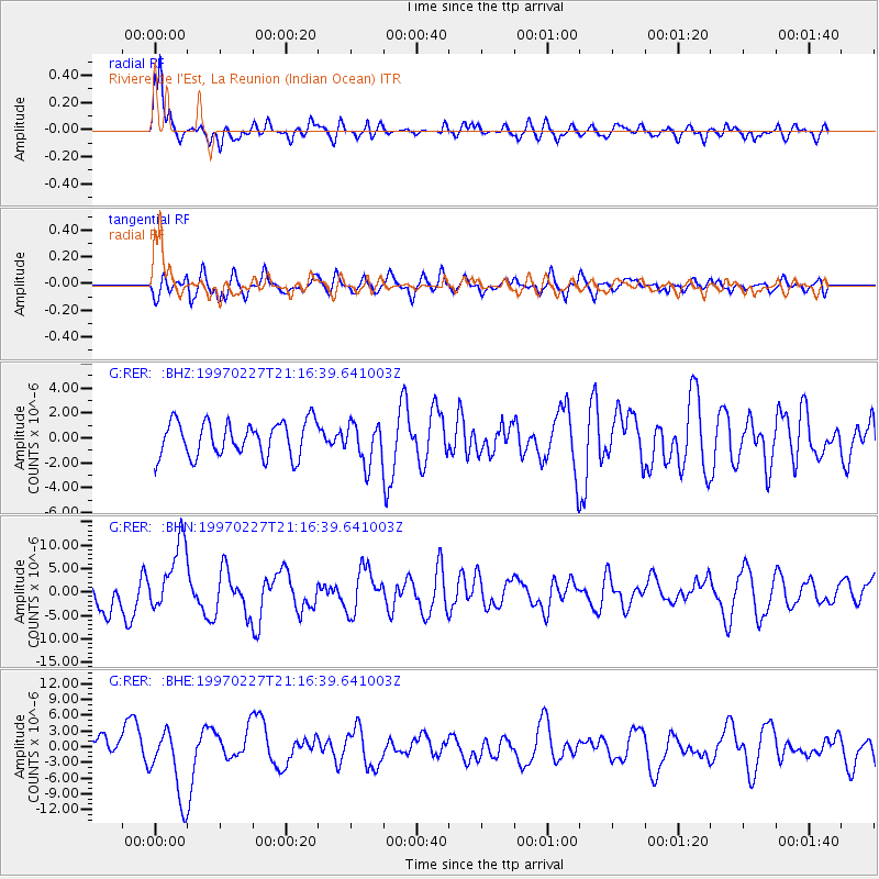
| Radial Match: |
83.7935 % |
| Radial Bump: |
375 |
| Transverse Match: |
56.471954 % |
| Transverse Bump: |
400 |
| SOD ConfigId: |
4480 |
| Insert Time: |
2010-02-26 23:44:29.216 +0000 |
| GWidth: |
2.5 |
| Max Bumps: |
400 |
| Tol: |
0.001 |
|
Signal To Noise
| Channel | StoN | STA | LTA |
| G:RER: :BHN:19970227T21:16:39.641003Z | 3.7412107 | 7.443966E-6 | 1.989721E-6 |
| G:RER: :BHE:19970227T21:16:39.641003Z | 5.2929378 | 6.718631E-6 | 1.2693577E-6 |
| G:RER: :BHZ:19970227T21:16:39.641003Z | 1.1467057 | 1.6020856E-6 | 1.3971202E-6 |
| Arrivals |
| Ps | 2.3 SECOND |
| PpPs | 7.7 SECOND |
| PsPs/PpSs | 10 SECOND |


