You are here: Home > Network List > TA - USArray Transportable Network (new EarthScope stations) Stations List
> Station G32A Webster, SD, USA > Earthquake Result Viewer
G32A Webster, SD, USA - Earthquake Result Viewer
| Earthquake location: |
Norwegian Sea |
| Earthquake latitude/longitude: |
73.0/5.7 |
| Earthquake time(UTC): |
2012/05/24 (145) 22:47:46 GMT |
| Earthquake Depth: |
10 km |
| Earthquake Magnitude: |
5.7 MB, 6.1 MS, 6.1 MW, 6.2 MW |
| Earthquake Catalog/Contributor: |
WHDF/NEIC |
|
| Network: |
TA USArray Transportable Network (new EarthScope stations) |
| Station: |
G32A Webster, SD, USA |
| Lat/Lon: |
45.26 N/97.50 W |
| Elevation: |
566 m |
|
| Distance: |
51.0 deg |
| Az: |
297.803 deg |
| Baz: |
21.669 deg |
| Ray Param: |
0.0676695 |
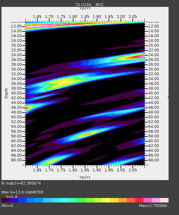
| Estimated Moho Depth: |
12.0 km |
| Estimated Crust Vp/Vs: |
1.60 |
| Assumed Crust Vp: |
6.552 km/s |
| Estimated Crust Vs: |
4.095 km/s |
| Estimated Crust Poisson's Ratio: |
0.18 |
|
| Radial Match: |
92.395874 % |
| Radial Bump: |
400 |
| Transverse Match: |
82.85917 % |
| Transverse Bump: |
400 |
| SOD ConfigId: |
446234 |
| Insert Time: |
2012-08-25 21:18:53.155 +0000 |
| GWidth: |
2.5 |
| Max Bumps: |
400 |
| Tol: |
0.001 |
|
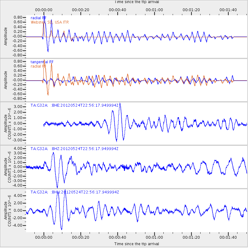
Signal To Noise
| Channel | StoN | STA | LTA |
| TA:G32A: :BHZ:20120524T22:56:17.949994Z | 6.1957903 | 9.9586E-7 | 1.6073172E-7 |
| TA:G32A: :BHN:20120524T22:56:17.949994Z | 2.0131657 | 7.8882823E-7 | 3.918347E-7 |
| TA:G32A: :BHE:20120524T22:56:17.949994Z | 2.5833373 | 4.6656163E-7 | 1.8060423E-7 |
| Arrivals |
| Ps | 1.2 SECOND |
| PpPs | 4.5 SECOND |
| PsPs/PpSs | 5.6 SECOND |


