You are here: Home > Network List > TA - USArray Transportable Network (new EarthScope stations) Stations List
> Station F36A Milaca, MN, USA > Earthquake Result Viewer
F36A Milaca, MN, USA - Earthquake Result Viewer
| Earthquake location: |
Norwegian Sea |
| Earthquake latitude/longitude: |
73.0/5.7 |
| Earthquake time(UTC): |
2012/05/24 (145) 22:47:46 GMT |
| Earthquake Depth: |
10 km |
| Earthquake Magnitude: |
5.7 MB, 6.1 MS, 6.1 MW, 6.2 MW |
| Earthquake Catalog/Contributor: |
WHDF/NEIC |
|
| Network: |
TA USArray Transportable Network (new EarthScope stations) |
| Station: |
F36A Milaca, MN, USA |
| Lat/Lon: |
45.86 N/93.52 W |
| Elevation: |
345 m |
|
| Distance: |
49.4 deg |
| Az: |
294.733 deg |
| Baz: |
22.534 deg |
| Ray Param: |
0.06871401 |
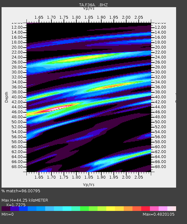
| Estimated Moho Depth: |
44.25 km |
| Estimated Crust Vp/Vs: |
1.73 |
| Assumed Crust Vp: |
6.571 km/s |
| Estimated Crust Vs: |
3.804 km/s |
| Estimated Crust Poisson's Ratio: |
0.25 |
|
| Radial Match: |
96.00795 % |
| Radial Bump: |
218 |
| Transverse Match: |
86.88474 % |
| Transverse Bump: |
336 |
| SOD ConfigId: |
446234 |
| Insert Time: |
2012-08-25 21:19:14.729 +0000 |
| GWidth: |
2.5 |
| Max Bumps: |
400 |
| Tol: |
0.001 |
|

Signal To Noise
| Channel | StoN | STA | LTA |
| TA:F36A: :BHZ:20120524T22:56:05.750012Z | 9.758932 | 6.9499237E-7 | 7.121602E-8 |
| TA:F36A: :BHN:20120524T22:56:05.750012Z | 8.172152 | 4.382993E-7 | 5.3633283E-8 |
| TA:F36A: :BHE:20120524T22:56:05.750012Z | 2.7273772 | 1.478005E-7 | 5.4191442E-8 |
| Arrivals |
| Ps | 5.2 SECOND |
| PpPs | 17 SECOND |
| PsPs/PpSs | 22 SECOND |


