You are here: Home > Network List > G - GEOSCOPE Stations List
> Station RER Riviere de l'Est, La Reunion (Indian Ocean) > Earthquake Result Viewer
RER Riviere de l'Est, La Reunion (Indian Ocean) - Earthquake Result Viewer

| Earthquake location: |
Greece |
| Earthquake latitude/longitude: |
40.1/21.7 |
| Earthquake time(UTC): |
1995/05/13 (133) 08:47:12 GMT |
| Earthquake Depth: |
13 km |
| Earthquake Magnitude: |
6.2 MB, 6.5 MS, 6.6 UNKNOWN, 6.5 MD |
| Earthquake Catalog/Contributor: |
WHDF/NEIC |
|
| Network: |
G GEOSCOPE |
| Station: |
RER Riviere de l'Est, La Reunion (Indian Ocean) |
| Lat/Lon: |
21.16 S/55.75 E |
| Elevation: |
834 m |
|
| Distance: |
68.8 deg |
| Az: |
145.883 deg |
| Baz: |
332.572 deg |
| Ray Param: |
0.056087818 |
| Estimated Moho Depth: |
16.25 km |
| Estimated Crust Vp/Vs: |
1.63 |
| Assumed Crust Vp: |
4.73 km/s |
| Estimated Crust Vs: |
2.897 km/s |
| Estimated Crust Poisson's Ratio: |
0.20 |
|
| Radial Match: |
80.277885 % |
| Radial Bump: |
400 |
| Transverse Match: |
48.7338 % |
| Transverse Bump: |
400 |
| SOD ConfigId: |
4480 |
| Insert Time: |
2010-02-26 23:44:31.172 +0000 |
| GWidth: |
2.5 |
| Max Bumps: |
400 |
| Tol: |
0.001 |
|
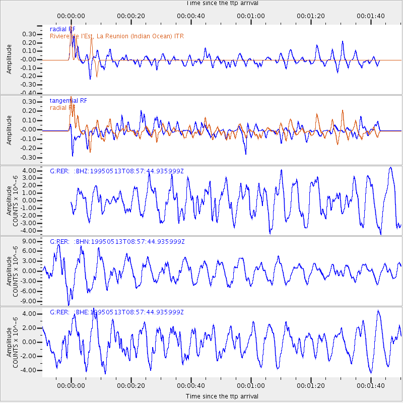
Signal To Noise
| Channel | StoN | STA | LTA |
| G:RER: :BHN:19950513T08:57:44.935999Z | 3.1465518 | 5.5685477E-6 | 1.7697301E-6 |
| G:RER: :BHE:19950513T08:57:44.935999Z | 1.612376 | 2.1539438E-6 | 1.3358817E-6 |
| G:RER: :BHZ:19950513T08:57:44.935999Z | 1.6374476 | 1.9266427E-6 | 1.1766133E-6 |
| Arrivals |
| Ps | 2.2 SECOND |
| PpPs | 8.8 SECOND |
| PsPs/PpSs | 11 SECOND |


