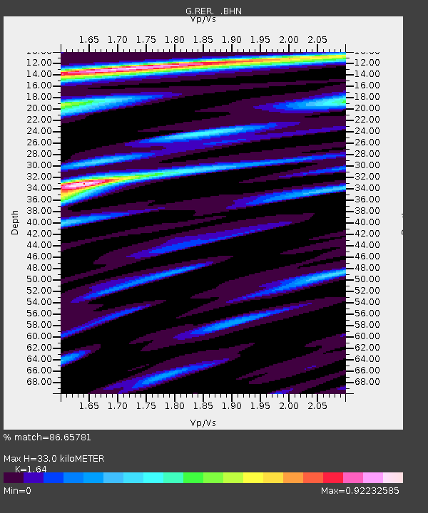
RER Riviere de l'Est, La Reunion (Indian Ocean) - Earthquake Result Viewer
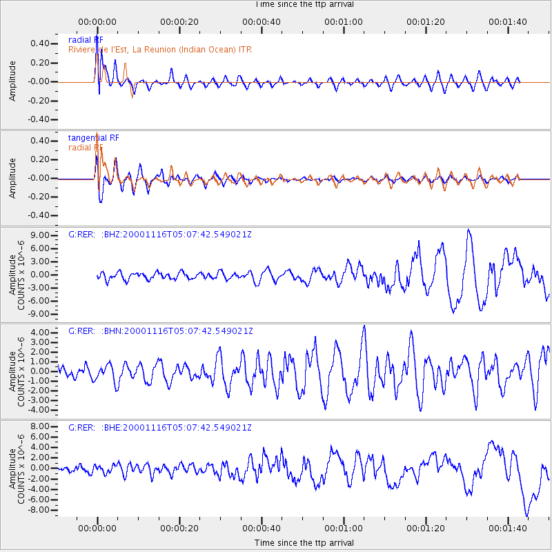
Earthquake location: New Ireland Region, P.N.G.
Earthquake latitude/longitude: -4.0/152.2
Earthquake time(UTC): 2000/11/16 (321) 04:54:56 GMT
Earthquake Depth: 33 km
Earthquake Magnitude: 6.0 MB, 8.2 MS, 8.0 MW, 8.0 ME
Earthquake Catalog/Contributor: WHDF/NEIC
Network: G GEOSCOPE
Station: RER Riviere de l'Est, La Reunion (Indian Ocean)
Lat/Lon: 21.16 S/55.75 E
Elevation: 834 m
Distance: 94.6 deg
Az: 248.509 deg
Baz: 96.012 deg
Ray Param: 0.041002132
Estimated Moho Depth: 33.0 km
Estimated Crust Vp/Vs: 1.64
Assumed Crust Vp: 4.73 km/s
Estimated Crust Vs: 2.884 km/s
Estimated Crust Poisson's Ratio: 0.20
Radial Match: 86.65781 %
Radial Bump: 400
Transverse Match: 75.48565 %
Transverse Bump: 400
SOD ConfigId: 3744
Insert Time: 2010-02-26 23:44:33.537 +0000
GWidth: 2.5
Max Bumps: 400
Tol: 0.001

Signal To Noise

ChannelStoNSTALTA
G:RER: :BHN:20001116T05:07:42.549021Z1.18967938.795446E-77.393124E-7
G:RER: :BHE:20001116T05:07:42.549021Z1.27903966.987253E-75.4628896E-7
G:RER: :BHZ:20001116T05:07:42.549021Z1.01804557.7505115E-77.6131283E-7
Arrivals
Ps4.5 SECOND
PpPs18 SECOND
PsPs/PpSs23 SECOND