You are here: Home > Network List > TA - USArray Transportable Network (new EarthScope stations) Stations List
> Station H37A Dierke Farm, Cannon Falls, MN, USA > Earthquake Result Viewer
H37A Dierke Farm, Cannon Falls, MN, USA - Earthquake Result Viewer
| Earthquake location: |
Norwegian Sea |
| Earthquake latitude/longitude: |
73.0/5.7 |
| Earthquake time(UTC): |
2012/05/24 (145) 22:47:46 GMT |
| Earthquake Depth: |
10 km |
| Earthquake Magnitude: |
5.7 MB, 6.1 MS, 6.1 MW, 6.2 MW |
| Earthquake Catalog/Contributor: |
WHDF/NEIC |
|
| Network: |
TA USArray Transportable Network (new EarthScope stations) |
| Station: |
H37A Dierke Farm, Cannon Falls, MN, USA |
| Lat/Lon: |
44.58 N/92.92 W |
| Elevation: |
321 m |
|
| Distance: |
50.4 deg |
| Az: |
293.578 deg |
| Baz: |
22.219 deg |
| Ray Param: |
0.06805775 |
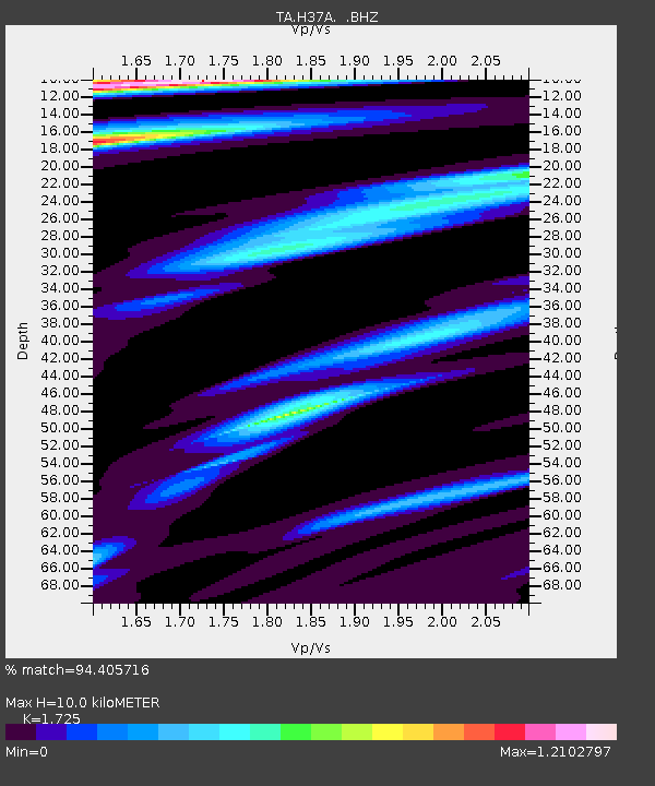
| Estimated Moho Depth: |
10.0 km |
| Estimated Crust Vp/Vs: |
1.73 |
| Assumed Crust Vp: |
6.571 km/s |
| Estimated Crust Vs: |
3.809 km/s |
| Estimated Crust Poisson's Ratio: |
0.25 |
|
| Radial Match: |
94.405716 % |
| Radial Bump: |
329 |
| Transverse Match: |
80.59722 % |
| Transverse Bump: |
400 |
| SOD ConfigId: |
446234 |
| Insert Time: |
2012-08-25 21:20:13.168 +0000 |
| GWidth: |
2.5 |
| Max Bumps: |
400 |
| Tol: |
0.001 |
|
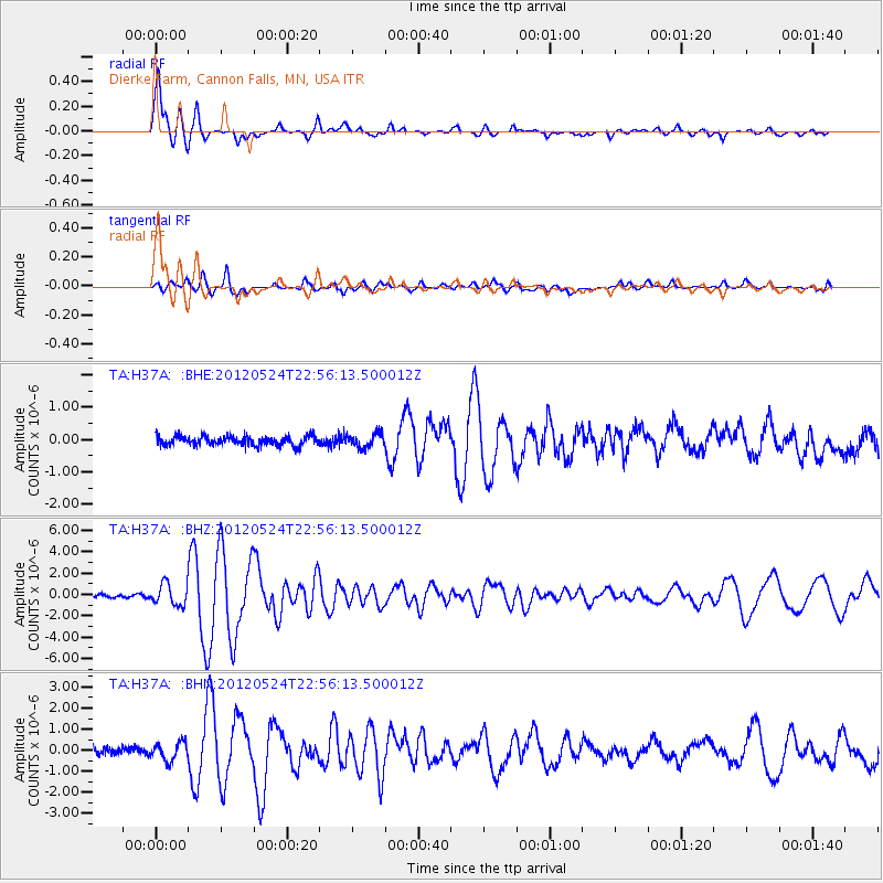
Signal To Noise
| Channel | StoN | STA | LTA |
| TA:H37A: :BHZ:20120524T22:56:13.500012Z | 8.250733 | 9.901167E-7 | 1.2000348E-7 |
| TA:H37A: :BHN:20120524T22:56:13.500012Z | 2.077122 | 4.2641562E-7 | 2.0529158E-7 |
| TA:H37A: :BHE:20120524T22:56:13.500012Z | 1.447453 | 2.0775146E-7 | 1.4352896E-7 |
| Arrivals |
| Ps | 1.2 SECOND |
| PpPs | 3.9 SECOND |
| PsPs/PpSs | 5.1 SECOND |


